IMAGES TAKEN NEAR TO
Sandbach Road, CONGLETON, CW12 4TE
Introduction
This page details the photographs taken nearby to Sandbach Road, CW12 4TE by members of the Geograph project.
The Geograph project started in 2005 with the aim of publishing, organising and preserving representative images for every square kilometre of Great Britain, Ireland and the Isle of Man.

There are currently over 7.5m images from over14,400 individuals and you can help contribute to the project by visiting https://www.geograph.org.uk
Image Map
Images are licensed for reuse under creativecommons.org/licenses/by-sa/2.0
Notes
- Clicking on the map will re-center to the selected point.
- The higher the marker number, the further away the image location is from the centre of the postcode.
Image Listing (7 Images Found)
Images are licensed for reuse under creativecommons.org/licenses/by-sa/2.0
Image
Details
Distance
5
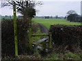
Stile and footpath
This path forms part of the Dane Valley Way. This picture shows the path leaving Sandy Lane near Congleton to run west. The finger post has the initials DVW which is the abbreviation used to mark the Dane Valley Way.
Image: © Colin Park
Taken: 16 Jan 2006
0.17 miles
6

On Dane Valley Way, NW of Bent Farm near Congleton
Image: © Colin Park
Taken: 3 Nov 2014
0.22 miles
7
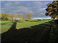
Late afternoon autumn sunlight, W of Sandy Lane, Congleotn
Image: © Colin Park
Taken: 3 Nov 2014
0.25 miles