IMAGES TAKEN NEAR TO
Peel Lane, CONGLETON, CW12 4RJ
Introduction
This page details the photographs taken nearby to Peel Lane, CW12 4RJ by members of the Geograph project.
The Geograph project started in 2005 with the aim of publishing, organising and preserving representative images for every square kilometre of Great Britain, Ireland and the Isle of Man.

There are currently over 7.5m images from over14,400 individuals and you can help contribute to the project by visiting https://www.geograph.org.uk
Image Map
Images are licensed for reuse under creativecommons.org/licenses/by-sa/2.0
Notes
- Clicking on the map will re-center to the selected point.
- The higher the marker number, the further away the image location is from the centre of the postcode.
Image Listing (19 Images Found)
Images are licensed for reuse under creativecommons.org/licenses/by-sa/2.0
Image
Details
Distance
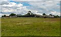
2
Field boundary leading towards Peel Farm
Image: © Jerry Evans
Taken: 1 Apr 2007
0.13 miles
3
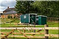
Peggy's Hut
Peggy's Hut at Bank Farm.
Image: © Peter McDermott
Taken: 13 Jul 2023
0.21 miles
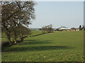
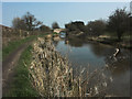
5
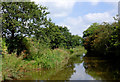
Macclesfield Canal south-east of Astbury, Cheshire
Image: © Roger D Kidd
Taken: 4 Sep 2014
0.22 miles
6
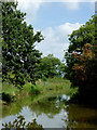
Macclesfield Canal south-east of Astbury, Cheshire
Image: © Roger D Kidd
Taken: 4 Sep 2014
0.22 miles
7
Macclesfield Canal from Peel Lane Bridge
Image: © Anthony Parkes
Taken: 19 May 2019
0.22 miles
8
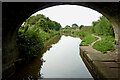
Macclesfield Canal near Astbury in Cheshire
Looking south-south-west through the arch of Peel Lane Bridge, No 79.
Image: © Roger Kidd
Taken: 9 Sep 2014
0.22 miles
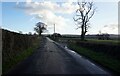
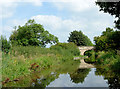
9
Macclesfield Canal approaching Peel Lane Bridge
Image: © Jerry Evans
Taken: 1 Apr 2007
0.22 miles
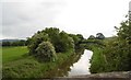
10
Macclesfield Canal east of Astbury, Cheshire
Looking north-east towards Peel Lane Bridge, No 79.
Image: © Roger D Kidd
Taken: 4 Sep 2014
0.23 miles