IMAGES TAKEN NEAR TO
Coniston Avenue, CONGLETON, CW12 4LY
Introduction
This page details the photographs taken nearby to Coniston Avenue, CW12 4LY by members of the Geograph project.
The Geograph project started in 2005 with the aim of publishing, organising and preserving representative images for every square kilometre of Great Britain, Ireland and the Isle of Man.

There are currently over 7.5m images from over14,400 individuals and you can help contribute to the project by visiting https://www.geograph.org.uk
Image Map
Images are licensed for reuse under creativecommons.org/licenses/by-sa/2.0
Notes
- Clicking on the map will re-center to the selected point.
- The higher the marker number, the further away the image location is from the centre of the postcode.
Image Listing (9 Images Found)
Images are licensed for reuse under creativecommons.org/licenses/by-sa/2.0
Image
Details
Distance
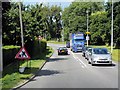
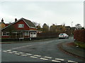
5
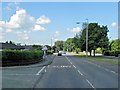
Padgbury Lane, West Heath
A road which forms a western boundary for the Congleton conurbation.
Image: © Jonathan Billinger
Taken: 16 Dec 2008
0.15 miles
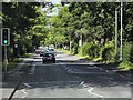
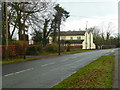
6
The Heath Farm
A pub in former farm buildings by Padgbury Lane.
It is family-friendly with a Wacky Warehouse for the youngsters.
Image: © Jonathan Billinger
Taken: 16 Dec 2008
0.19 miles
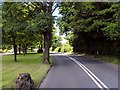
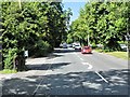
7
Birch Road, West Heath
Housing on the western outskirts of Congleton.
Image: © Jonathan Billinger
Taken: 16 Dec 2008
0.23 miles