IMAGES TAKEN NEAR TO
West Road, CONGLETON, CW12 4HD
Introduction
This page details the photographs taken nearby to West Road, CW12 4HD by members of the Geograph project.
The Geograph project started in 2005 with the aim of publishing, organising and preserving representative images for every square kilometre of Great Britain, Ireland and the Isle of Man.

There are currently over 7.5m images from over14,400 individuals and you can help contribute to the project by visiting https://www.geograph.org.uk
Image Map
Images are licensed for reuse under creativecommons.org/licenses/by-sa/2.0
Notes
- Clicking on the map will re-center to the selected point.
- The higher the marker number, the further away the image location is from the centre of the postcode.
Image Listing (38 Images Found)
Images are licensed for reuse under creativecommons.org/licenses/by-sa/2.0
Image
Details
Distance
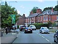
1
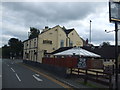
Waggon and Horses Public House, Congleton
Image: © Glyn Drury
Taken: 6 Sep 2009
0.04 miles
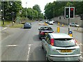
2
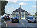
Tesco Express, West Road
Formerly the Waggon and Horses public house (see Image]).
Image: © David Dixon
Taken: 17 Jul 2014
0.05 miles
3
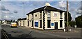
Tesco Express
Tesco Express in Congleton.
Image: © Peter McDermott
Taken: 13 Jul 2023
0.05 miles
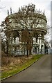
7
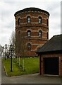
Water Tower
Converted water tower, now a domestic dwelling.
Image: © Peter McDermott
Taken: 6 Mar 2021
0.15 miles
9
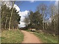
Path at Astbury Mere Country Park
Image: © Jonathan Hutchins
Taken: 25 Mar 2018
0.16 miles
10
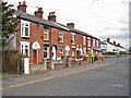
Terraced housing in Holmes Chapel Road
Located on the junction with Back Lane.
Image: © Richard Dorrell
Taken: 19 Mar 2012
0.17 miles