IMAGES TAKEN NEAR TO
Lamberts Lane, CONGLETON, CW12 4EP
Introduction
This page details the photographs taken nearby to Lamberts Lane, CW12 4EP by members of the Geograph project.
The Geograph project started in 2005 with the aim of publishing, organising and preserving representative images for every square kilometre of Great Britain, Ireland and the Isle of Man.

There are currently over 7.5m images from over14,400 individuals and you can help contribute to the project by visiting https://www.geograph.org.uk
Image Map
Images are licensed for reuse under creativecommons.org/licenses/by-sa/2.0
Notes
- Clicking on the map will re-center to the selected point.
- The higher the marker number, the further away the image location is from the centre of the postcode.
Image Listing (3 Images Found)
Images are licensed for reuse under creativecommons.org/licenses/by-sa/2.0
Image
Details
Distance
1
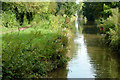
Site of former swing bridge south of Congleton, Cheshire
This is about a hundred metres north-east of the current Billy Tight's Footbridge, No 78.
Image: © Roger D Kidd
Taken: 4 Sep 2014
0.24 miles
2
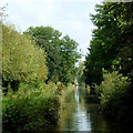
Macclesfield Canal south of Congleton, Cheshire
About a hundred metres north-east of the current Billy Tight's Footbridge (No 78) is this narrowing of the channel.
Image: © Roger D Kidd
Taken: 4 Sep 2014
0.25 miles
3
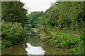
Macclesfield Canal near Congleton in Cheshire
This narrowing is about a mile south of Congleton town centre, looking south-west towards Kidsgrove.
Image: © Roger Kidd
Taken: 9 Sep 2014
0.25 miles