IMAGES TAKEN NEAR TO
Astbury Street, CONGLETON, CW12 4EG
Introduction
This page details the photographs taken nearby to Astbury Street, CW12 4EG by members of the Geograph project.
The Geograph project started in 2005 with the aim of publishing, organising and preserving representative images for every square kilometre of Great Britain, Ireland and the Isle of Man.

There are currently over 7.5m images from over14,400 individuals and you can help contribute to the project by visiting https://www.geograph.org.uk
Image Map
Images are licensed for reuse under creativecommons.org/licenses/by-sa/2.0
Notes
- Clicking on the map will re-center to the selected point.
- The higher the marker number, the further away the image location is from the centre of the postcode.
Image Listing (34 Images Found)
Images are licensed for reuse under creativecommons.org/licenses/by-sa/2.0
Image
Details
Distance
1
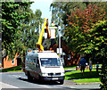
Changing the light bulb
The gentleman standing in the cherry-picker is changing the bulb in the street-light on Galbraith Close. He has gained himself a bit of an audience, and the small gentleman on the right looks as if he might consider this to be his future career- especially as steam engine drivers are no longer required very often.
Image: © Jonathan Kington
Taken: 2 Sep 2011
0.08 miles
2
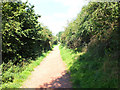
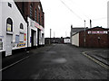
Down the hill
Having reached the top of hill in Image the path descends to Astbury Street and Galbraith Close on the edge of Congleton.
Astbury Mere was originally a sand quarry, in 1984 operations ceased and the quarry closed. For over 50 years the local residents had put up with a noisy major industry on their doorsteps, wildlife started to gain a foothold and it was thought that the area might become a local amenity. But a proposal was put forward to construct a major industrial complex on the site. Dismayed, the locals set up an action group to fight the proposals and intensive negotiations were started. After years of uncertainty the landowners agreed to sub divide their estate; half the site would instead be developed for housing whilst the remainder would be given over as open space and so began the creation of Congleton’s first Country Park. The action group then became the Astbury Mere Trust, a registered charity and a limited company whose main objectives are to: “Provide for the benefit of the inhabitants of Congleton and district a managed and maintained country park at Astbury Mere in perpetuity for recreation or other leisure time occupation with the object of improving the conditions of life for the said inhabitants”. Since its opening in 1989 the Country Park has become a valued recreational resource for the inhabitants of Congleton and beyond. In this time the Park has matured, not only in physical terms with the growth of trees and shrubs but also in its evolution as an important outdoor recreational and learning resource. Although still owned by the Trust, Astbury Mere Country Park is managed by Cheshire East Council ( http://www.cheshireeast.gov.uk/leisure,_culture_and_tourism/ranger_service/countryside_sites/congleton_area/astbury_mere_country_park.aspx ).
My thanks to Matthew Axford, Countryside Ranger, for providing a much more detailed history than there was space for here.
Image: © Jonathan Kington
Taken: 2 Sep 2011
0.10 miles
3
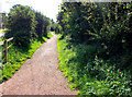
Entering the park
Entering Astbury Mere Country Park from the entrance at the end of Astbury Street.
Astbury Mere was originally a sand quarry, in 1984 operations ceased and the quarry closed. For over 50 years the local residents had put up with a noisy major industry on their doorsteps, wildlife started to gain a foothold and it was thought that the area might become a local amenity. But a proposal was put forward to construct a major industrial complex on the site. Dismayed, the locals set up an action group to fight the proposals and intensive negotiations were started. After years of uncertainty the landowners agreed to sub divide their estate; half the site would instead be developed for housing whilst the remainder would be given over as open space and so began the creation of Congleton’s first Country Park. The action group then became the Astbury Mere Trust, a registered charity and a limited company whose main objectives are to: “Provide for the benefit of the inhabitants of Congleton and district a managed and maintained country park at Astbury Mere in perpetuity for recreation or other leisure time occupation with the object of improving the conditions of life for the said inhabitants”. Since its opening in 1989 the Country Park has become a valued recreational resource for the inhabitants of Congleton and beyond. In this time the Park has matured, not only in physical terms with the growth of trees and shrubs but also in its evolution as an important outdoor recreational and learning resource. Although still owned by the Trust, Astbury Mere Country Park is managed by Cheshire East Council ( http://www.cheshireeast.gov.uk/leisure,_culture_and_tourism/ranger_service/countryside_sites/congleton_area/astbury_mere_country_park.aspx ).
My thanks to Matthew Axford, Countryside Ranger, for providing a much more detailed history than there was space for here.
Image: © Jonathan Kington
Taken: 2 Sep 2011
0.13 miles
4
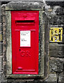
Postbox on Booth Street
This George V post box is located opposite the end of Image
Image: © Jonathan Kington
Taken: 20 Mar 2011
0.14 miles
5
Queen Street
Looking the full length of Queen Street from its junction with Silk Street to the junction with Booth Street. Image is on the left and the end of Image on the right.
Image: © Jonathan Kington
Taken: 20 Mar 2011
0.14 miles
6
St. Mary's Roman Catholic Chapel, Congleton
Image: © nick macneill
Taken: 1 Sep 2011
0.15 miles
7
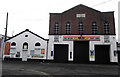
TBE Fast-fit Centre
Although it is now a garage, this building was erected in 1836. Although part of the date stone (Image) has been painted over it is still possible to see that it was originally a chapel for the Methodist New Connexion.
The Methodist New Connexion was formed in 1797 by a breakaway movement from the Wesleyan Methodists led by Alexander Kilham, a minister of a Methodist circuit in Sheffield. Kilham was an outspoken man who disagreed with the Wesleyan idea of putting the position of minister above that of the common member and that there should be free elections of class-leaders and stewards, and equal representation with ministers at Conference. They also contended that the ministry should possess no official authority or pastoral prerogative, but should merely carry into effect the decisions of majorities in the different meetings. The Connexion lasted until 1907 when it merged with the Bible Christian Church and the United Methodist Free Churches to form the United Methodist Church. At the time of the merger the Methodist New Connexion consisted of 250 ministers and 45,000 members.
Image: © Jonathan Kington
Taken: 20 Mar 2011
0.15 miles
8
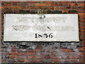
Date stone on the garage
This date plaque is above entrance doors to the Image Although the date has been left black the letters above have been painted over, if we look carefully the words Methodist New Connexion can be made out- indicating that this was once a chapel.
The Methodist New Connexion was formed in 1797 by a breakaway movement from the Wesleyan Methodists led by Alexander Kilham, a minister of a Methodist circuit in Sheffield. Kilham was an outspoken man who disagreed with the Wesleyan idea of putting the position of minister above that of the common member and that there should be free elections of class-leaders and stewards, and equal representation with ministers at Conference. They also contended that the ministry should possess no official authority or pastoral prerogative, but should merely carry into effect the decisions of majorities in the different meetings. The Connexion lasted until 1907 when it merged with the Bible Christian Church and the United Methodist Free Churches to form the United Methodist Church. At the time of the merger the Methodist New Connexion consisted of 250 ministers and 45,000 members.
Image: © Jonathan Kington
Taken: 20 Mar 2011
0.15 miles
9
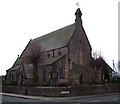
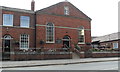
Church of St James the Great
Looking at the north and west elevations.
The first stone to be laid in the building of the Church of St James the Great was done by the then High Steward of the Borough of Congleton, Randle Wilbraham Esq, in May of 1847. The architect was James Trubshaw of Newcastle under Lyme; the chief contractor was Samuel Faram of Odd Rode with the woodwork being under the direction of Edward Massey of Lawton. The building work was paid for by public subscription along with grants from the Chester Diocesan Society, the Incorporated Society and the Church Commissioners. It is built in the style of the transitional period of Early English; this is evident in the steep roof that forms an equilateral triangle to the windows and doorways. The church is built of local, Cloud-side, gritstone with a Westmoreland slate roof. The church was consecrated by the Bishop of Chester Dr Graham on Wednesday 27th January 1849
Image: © Jonathan Kington
Taken: 20 Mar 2011
0.16 miles
10
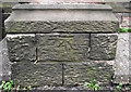
Bench mark on the Church of St James the Great
Located at the base of one of the buttresses on the east end of the church (Image). For more information on this and other bench marks go to http://www.bench-marks.org.uk/bm37363 .
Image: © Jonathan Kington
Taken: 20 Mar 2011
0.16 miles