IMAGES TAKEN NEAR TO
Sandy Lane, CONGLETON, CW12 4AW
Introduction
This page details the photographs taken nearby to Sandy Lane, CW12 4AW by members of the Geograph project.
The Geograph project started in 2005 with the aim of publishing, organising and preserving representative images for every square kilometre of Great Britain, Ireland and the Isle of Man.

There are currently over 7.5m images from over14,400 individuals and you can help contribute to the project by visiting https://www.geograph.org.uk
Image Map
Images are licensed for reuse under creativecommons.org/licenses/by-sa/2.0
Notes
- Clicking on the map will re-center to the selected point.
- The higher the marker number, the further away the image location is from the centre of the postcode.
Image Listing (36 Images Found)
Images are licensed for reuse under creativecommons.org/licenses/by-sa/2.0
Image
Details
Distance
1
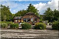
Astbury Mere
Buildings at the Astbury Mere Country Park.
Image: © Peter McDermott
Taken: 13 Jul 2023
0.01 miles
2
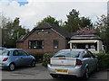
Astbury Mere Visitor Centre
In the northern car park.
Image: © Stephen Craven
Taken: 3 May 2015
0.01 miles
3
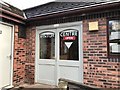
Entrance to Astbury Mere Visitor Centre
Image: © Jonathan Hutchins
Taken: 6 Jan 2018
0.01 miles
4
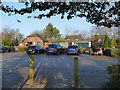
Astbury Mere - northern car park
The building in the background is the visitor centre Image
Image: © Stephen Craven
Taken: 1 Jan 2020
0.02 miles
5
Emergency access gate at Astbury Mere Country Park
Image: © Jonathan Hutchins
Taken: 25 Mar 2018
0.03 miles
6
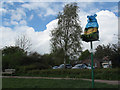
Sandy Bear, Astbury Mere Country Park
The bear is the symbol of Congleton, and this one keeps watch over the mere at Astbury from his elevated perch, like a lifeguard.
Image: © Stephen Craven
Taken: 3 May 2015
0.04 miles
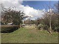
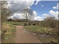
7
Footpath junction
The footpath to the left and the one in the distance lead to the car park, the path sweeping to the right carries on around the lake at Astbury Mere Country Park. Previously very difficult to negotiate with wheelchairs, the path was relayed during the Winter of 2010/11 and is now fully accessible.
Astbury Mere was originally a sand quarry, in 1984 operations ceased and the quarry closed. For over 50 years the local residents had put up with a noisy major industry on their doorsteps, wildlife started to gain a foothold and it was thought that the area might become a local amenity. But a proposal was put forward to construct a major industrial complex on the site. Dismayed, the locals set up an action group to fight the proposals and intensive negotiations were started. After years of uncertainty the landowners agreed to sub divide their estate; half the site would instead be developed for housing whilst the remainder would be given over as open space and so began the creation of Congleton’s first Country Park. The action group then became the Astbury Mere Trust, a registered charity and a limited company whose main objectives are to: “Provide for the benefit of the inhabitants of Congleton and district a managed and maintained country park at Astbury Mere in perpetuity for recreation or other leisure time occupation with the object of improving the conditions of life for the said inhabitants”. Since its opening in 1989 the Country Park has become a valued recreational resource for the inhabitants of Congleton and beyond. In this time the Park has matured, not only in physical terms with the growth of trees and shrubs but also in its evolution as an important outdoor recreational and learning resource. Although still owned by the Trust, Astbury Mere Country Park is managed by Cheshire East Council ( http://www.cheshireeast.gov.uk/leisure,_culture_and_tourism/ranger_service/countryside_sites/congleton_area/astbury_mere_country_park.aspx ).
My thanks to Matthew Axford, Countryside Ranger, for providing a much more detailed history than there was space for here.
Image: © Jonathan Kington
Taken: 2 Sep 2011
0.04 miles
8
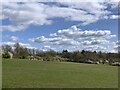
Grassland and shrubs bordering Astbury Mere
Image: © Jonathan Hutchins
Taken: 7 Apr 2021
0.05 miles
10
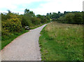
Heading around the lake
During the Winter of 2010/11 the path, which had been impossible for wheelchairs, was upgraded and fully accessible. It follows the lake edge on Astbury Mere Country Park, making an enjoyable walk, run or ride for everybody.
Astbury Mere was originally a sand quarry, in 1984 operations ceased and the quarry closed. For over 50 years the local residents had put up with a noisy major industry on their doorsteps, wildlife started to gain a foothold and it was thought that the area might become a local amenity. But a proposal was put forward to construct a major industrial complex on the site. Dismayed, the locals set up an action group to fight the proposals and intensive negotiations were started. After years of uncertainty the landowners agreed to sub divide their estate; half the site would instead be developed for housing whilst the remainder would be given over as open space and so began the creation of Congleton’s first Country Park. The action group then became the Astbury Mere Trust, a registered charity and a limited company whose main objectives are to: “Provide for the benefit of the inhabitants of Congleton and district a managed and maintained country park at Astbury Mere in perpetuity for recreation or other leisure time occupation with the object of improving the conditions of life for the said inhabitants”. Since its opening in 1989 the Country Park has become a valued recreational resource for the inhabitants of Congleton and beyond. In this time the Park has matured, not only in physical terms with the growth of trees and shrubs but also in its evolution as an important outdoor recreational and learning resource. Although still owned by the Trust, Astbury Mere Country Park is managed by Cheshire East Council ( http://www.cheshireeast.gov.uk/leisure,_culture_and_tourism/ranger_service/countryside_sites/congleton_area/astbury_mere_country_park.aspx ).
My thanks to Matthew Axford, Countryside Ranger, for providing a much more detailed history than there was space for here.
Image: © Jonathan Kington
Taken: 2 Sep 2011
0.07 miles