IMAGES TAKEN NEAR TO
Bollin Drive, CONGLETON, CW12 3SJ
Introduction
This page details the photographs taken nearby to Bollin Drive, CW12 3SJ by members of the Geograph project.
The Geograph project started in 2005 with the aim of publishing, organising and preserving representative images for every square kilometre of Great Britain, Ireland and the Isle of Man.

There are currently over 7.5m images from over14,400 individuals and you can help contribute to the project by visiting https://www.geograph.org.uk
Image Map
Images are licensed for reuse under creativecommons.org/licenses/by-sa/2.0
Notes
- Clicking on the map will re-center to the selected point.
- The higher the marker number, the further away the image location is from the centre of the postcode.
Image Listing (44 Images Found)
Images are licensed for reuse under creativecommons.org/licenses/by-sa/2.0
Image
Details
Distance
1
Congleton War Memorial Hospital
A small but very busy community hospital on Canal Road. The War Memorial Hospital has a minor injuries department, various clinics and an elderly care unit.
Image: © Jonathan Kington
Taken: 15 Dec 2010
0.07 miles
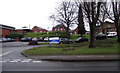
2
Close up, yarn bombed Elizabeth II postbox on Canal Road, Congleton
Postbox No. CW12 67.
Image: © JThomas
Taken: 30 May 2024
0.10 miles
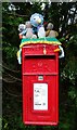
3

Yarn bombed Elizabeth II postbox on Canal Road, Congleton
Postbox No. CW12 67.
Image: © JThomas
Taken: 30 May 2024
0.10 miles
4

Sign for the Wharf Inn
This sign, depicting two workers on a wharfside, belongs to the Image located near Image, from which it gets its name. Congleton Wharf on the Macclesfield Canal was originally owned by the Macclesfield Canal Company and provided wharfage and warehousing, after the decline of the canal industry the wharf was allowed to go derelict. At the beginning of the 21st century developers rescued the one remaining building, converting it into flats and adding further dwellings on either side.
Image: © Jonathan Kington
Taken: 15 Dec 2010
0.12 miles
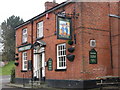
5

Wharf Inn
Situated on Canal Road and very close to Image, which it is named after. Although there were a few cars in the car-park it didn't look as if there was much going on. For a close-up of the sign see Image
Image: © Jonathan Kington
Taken: 15 Dec 2010
0.12 miles
6

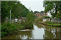
Canal Road and Aqueduct, Congleton, Cheshire
Image: © Roger D Kidd
Taken: 28 Aug 2007
0.13 miles
8
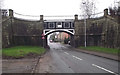
Dog Lane aqueduct
Dog Lane aqueduct carries the Macclesfield Canal over Canal Road and is viewed here looking towards Congleton. It was designed by Telford as a cast iron trough constructed with plates riveted together and supported by stone piers at each end, further support is provided by the cast iron "arch" and the whole structure finished with iron railings at the top on both sides. The aqueduct gets its name from a small side road, the junction of which is visible in the foreground.
Image: © Jonathan Kington
Taken: 15 Dec 2010
0.14 miles
9
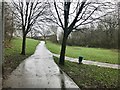
Footpath leading to Thames Close, Congleton
Image: © Jonathan Hutchins
Taken: 18 Mar 2017
0.15 miles
10
Dog Lane Aqueduct near Congleton in Cheshire
Looking north-east as the Macclesfield Canal crosses Canal Road in Congleton. The dog feels very at home exercising by this aqueduct.
Image: © Roger Kidd
Taken: 9 Sep 2014
0.15 miles