IMAGES TAKEN NEAR TO
Gosberryhole Lane, CONGLETON, CW12 3QL
Introduction
This page details the photographs taken nearby to Gosberryhole Lane, CW12 3QL by members of the Geograph project.
The Geograph project started in 2005 with the aim of publishing, organising and preserving representative images for every square kilometre of Great Britain, Ireland and the Isle of Man.

There are currently over 7.5m images from over14,400 individuals and you can help contribute to the project by visiting https://www.geograph.org.uk
Image Map
Images are licensed for reuse under creativecommons.org/licenses/by-sa/2.0
Notes
- Clicking on the map will re-center to the selected point.
- The higher the marker number, the further away the image location is from the centre of the postcode.
Image Listing (21 Images Found)
Images are licensed for reuse under creativecommons.org/licenses/by-sa/2.0
Image
Details
Distance
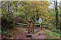
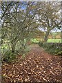
1

Walking in autumn
On the Gritstone Trail south of Bosley Cloud.
Image: © John H Darch
Taken: 19 Nov 2021
0.04 miles
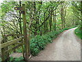
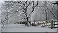
3
Southern entrance to The Cloud
This marks the boundary of the National Trust
Image: © Raymond Knapman
Taken: 19 May 2010
0.06 miles
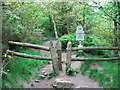
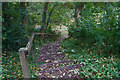
4
Gritstone Trail signpost at Timbersbrook
The trail descends steep steps from the road down to Timbersbrook car park
Image: © Raymond Knapman
Taken: 19 May 2010
0.07 miles
7
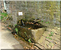
Water spout at side of The Cloud
Situated in Timbersbrook, the sign states that the water should be boiled before human consumption. I tend to agree.
Image: © Neil Lewin
Taken: 4 May 2006
0.16 miles
8
A lot of steps
Timbersbrook Country Park
Image: © Anthony O'Neil
Taken: 22 Oct 2015
0.19 miles
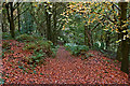
10
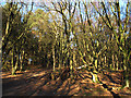
Path through the Cloud plantation
The plantation on the western side of the hill is a National Trust property, and this lower end of it is mostly deciduous trees. The path leads to the summit of the hill.
Image: © Stephen Craven
Taken: 4 Dec 2016
0.21 miles