IMAGES TAKEN NEAR TO
Cloudside, CONGLETON, CW12 3QG
Introduction
This page details the photographs taken nearby to Cloudside, CW12 3QG by members of the Geograph project.
The Geograph project started in 2005 with the aim of publishing, organising and preserving representative images for every square kilometre of Great Britain, Ireland and the Isle of Man.

There are currently over 7.5m images from over14,400 individuals and you can help contribute to the project by visiting https://www.geograph.org.uk
Image Map
Images are licensed for reuse under creativecommons.org/licenses/by-sa/2.0
Notes
- Clicking on the map will re-center to the selected point.
- The higher the marker number, the further away the image location is from the centre of the postcode.
Image Listing (35 Images Found)
Images are licensed for reuse under creativecommons.org/licenses/by-sa/2.0
Image
Details
Distance
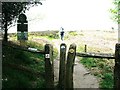
1
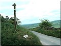
Gritstone Trail signpost
The post marks the path up to The Cloud
Image: © Raymond Knapman
Taken: 19 May 2010
0.02 miles
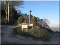
2
Access to Bosley Cloud summit
Fingerpost for Staffordshire Way and Gritstone Trail walkers.
Image: © Peter Turner
Taken: 24 Jan 2013
0.02 miles
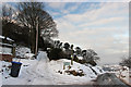
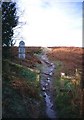
3
Track off Red Lane
The private track to the left leads to a couple of farms but is also a public footpath leading to the summit of the Cloud. See Image for a similar view in a harder winter than this.
Image: © Stephen Craven
Taken: 4 Dec 2016
0.02 miles
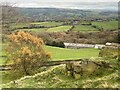
5
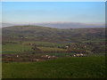
View north-east from Red Lane
The view includes the transmitter mast on Croker Hill 5km away, and part of Bosley Reservoir below it.
Image: © Stephen Craven
Taken: 4 Dec 2016
0.03 miles
7
Bosley Cloud
Path up this gritstone Pennine outlier on the Cheshire Staffordshire border. An ideal hill for flying, as demonstrated by the NO-tice.
Image: © Richard Webb
Taken: Unknown
0.10 miles
8
Cloudside, the road and farm of that name
Image: © Peter Turner
Taken: 24 Jan 2013
0.10 miles
9
National Trust entrance sign for The Cloud Summit
Image: © Raymond Knapman
Taken: 19 May 2010
0.11 miles
10
Cloud Side Farm
Almost hidden in a fold of the hills south-east of The Cloud.
Image: © John H Darch
Taken: 19 Nov 2021
0.13 miles