IMAGES TAKEN NEAR TO
Gorse Lane, CONGLETON, CW12 3NR
Introduction
This page details the photographs taken nearby to Gorse Lane, CW12 3NR by members of the Geograph project.
The Geograph project started in 2005 with the aim of publishing, organising and preserving representative images for every square kilometre of Great Britain, Ireland and the Isle of Man.

There are currently over 7.5m images from over14,400 individuals and you can help contribute to the project by visiting https://www.geograph.org.uk
Image Map
Images are licensed for reuse under creativecommons.org/licenses/by-sa/2.0
Notes
- Clicking on the map will re-center to the selected point.
- The higher the marker number, the further away the image location is from the centre of the postcode.
Image Listing (12 Images Found)
Images are licensed for reuse under creativecommons.org/licenses/by-sa/2.0
Image
Details
Distance
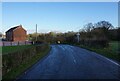
1
Gorse Farm, Gorse Lane
Gorse Farm was built in 1880 according to a plaque by the door.
Image: © Steve Lewin
Taken: 13 Jul 2006
0.02 miles
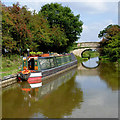
2
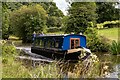
Halcyon Dawn
Halcyon Dawn on the Macclesfield Canal.
Image: © Peter McDermott
Taken: 13 Jul 2023
0.16 miles
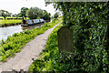
3
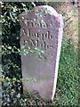
Old milemarker by the Macclesfield Canal, Newbold Astbury parish
Milemarker by the Macclesfield Canal, in parish of Newbold Astbury (Congleton District).
Inscription reads:-
From Marple
23 Miles
Surveyed
Milestone Society National ID: MAC-23
Image: © Milestone Society
Taken: Unknown
0.18 miles
4
Moored narrowboat near Astbury, Cheshire
This is the Macclesfield Canal, approaching Henshalls Bridge, No 80. The bridge carries Dodd's Lane.
Image: © Roger D Kidd
Taken: 4 Sep 2014
0.18 miles
5
Macclesfield Canal Mile Stone (23 miles from Marple)
According to the canal society's website, these stones resembling grave markers are unique to the Macclesfield and Cromford canals. The Macclesfield's milestones had mostly been buried during the second world war as a precaution against enemy soldiers using them to find their way. All but three stones were dug up and re-erected by volunteers in the 1980s. This one, showing :-
From Marple 23 Miles (Other side)
From Hall Green 3¼ Mile (This side)
Image: © Brian Deegan
Taken: 13 May 2023
0.18 miles
6
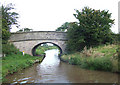
Henshalls Bridge, Macclesfield Canal, Astbury, Cheshire
Bridge No 80 counting from Marple Junction.
Image: © Roger D Kidd
Taken: 28 Aug 2007
0.19 miles
7
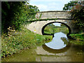
Henshalls Bridge south-east of Astbury, Cheshire
This is the Macclesfield Canal, approaching Henshalls Bridge, No 80. The bridge carries Dodd's Lane.
Image: © Roger D Kidd
Taken: 4 Sep 2014
0.20 miles
8
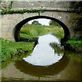
Henshalls Bridge south-east of Astbury, Cheshire
This is the Macclesfield Canal, approaching Henshalls Bridge, No 80. The bridge carries Dodd's Lane.
Image: © Roger D Kidd
Taken: 4 Sep 2014
0.20 miles
9

Macclesfield Canal: Hensall's Bridge No 80
Image: © Dr Neil Clifton
Taken: 1 Apr 2015
0.20 miles