IMAGES TAKEN NEAR TO
Mow Lane, CONGLETON, CW12 3NN
Introduction
This page details the photographs taken nearby to Mow Lane, CW12 3NN by members of the Geograph project.
The Geograph project started in 2005 with the aim of publishing, organising and preserving representative images for every square kilometre of Great Britain, Ireland and the Isle of Man.

There are currently over 7.5m images from over14,400 individuals and you can help contribute to the project by visiting https://www.geograph.org.uk
Image Map
Images are licensed for reuse under creativecommons.org/licenses/by-sa/2.0
Notes
- Clicking on the map will re-center to the selected point.
- The higher the marker number, the further away the image location is from the centre of the postcode.
Image Listing (5 Images Found)
Images are licensed for reuse under creativecommons.org/licenses/by-sa/2.0
Image
Details
Distance
1
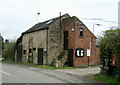
Barn with parish council notice board
Opposite the Horse Shoe Inn.
Image: © John H Darch
Taken: 9 Apr 2021
0.14 miles
3
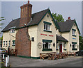
Horse Shoe Inn
A pleasant isolated country pub with beer garden and play area in Newbold Astbury. It dates from 1774.
Image: © Neil Lewin
Taken: 8 Jun 2007
0.16 miles
4
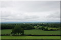
Fields near Corda Well Tank
This is the bottom of the Mow Cop ridge where the Cheshire Plain begins.
Image: © Bill Boaden
Taken: 19 Jun 2020
0.18 miles
5
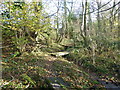
Quirky three plank bridges
These criss cross a brook on the path from Limekiln Farm to Mow Road. Marker post seen in middle distance.
Image: © Raymond Knapman
Taken: 4 Nov 2014
0.24 miles