IMAGES TAKEN NEAR TO
Kestrel Close, CONGLETON, CW12 3FA
Introduction
This page details the photographs taken nearby to Kestrel Close, CW12 3FA by members of the Geograph project.
The Geograph project started in 2005 with the aim of publishing, organising and preserving representative images for every square kilometre of Great Britain, Ireland and the Isle of Man.

There are currently over 7.5m images from over14,400 individuals and you can help contribute to the project by visiting https://www.geograph.org.uk
Image Map
Images are licensed for reuse under creativecommons.org/licenses/by-sa/2.0
Notes
- Clicking on the map will re-center to the selected point.
- The higher the marker number, the further away the image location is from the centre of the postcode.
Image Listing (46 Images Found)
Images are licensed for reuse under creativecommons.org/licenses/by-sa/2.0
Image
Details
Distance
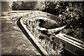
1
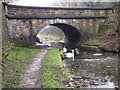
Bridge 77, Lambert's Lane
Bridge 77 not only carries Lambert's Lane over the Macclesfield Canal but, like Bridge 76 (Image) also allowed the towing horse to change sides without releasing the tow. It is thought that these bridges were installed to allow through traffic to by-pass Congleton Wharf (Image). There was a pair of Swans and a motley collection of waterfowl sharing a patch of unfrozen water.
The Macclesfield Canal was one of the last narrow canals to be built and runs approximately 28 miles from Harding's Wood Junction on the Trent and Mersey Canal, along the edge of the western Pennine hills to Marple Junction on the Peak Forest Canal. It was surveyed by Thomas Telford with construction starting in 1826, with William Crosley doing the engineering. The canal opened in November 1831 having cost a total of £320,000.
Image: © Jonathan Kington
Taken: 15 Dec 2010
0.11 miles
2

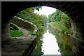
Bridge 77, Lambert's Lane change-over bridge
Like bridge 76 (Image), this is another change-over bridge that allowed the horse pulling the narrowboat to change sides without releasing the tow rope. These two cross-over bridges are thought to have allowed through traffic by-pass the Image thus saving them a lot of time. This bridge, however, is slightly different from the other in that the horse path is separated from Lambert's Lane by a buttress.
The Macclesfield Canal was one of the last narrow canals to be built and runs approximately 28 miles from Harding's Wood Junction on the Trent and Mersey Canal, along the edge of the western Pennine hills to Marple Junction on the Peak Forest Canal. It was surveyed by Thomas Telford with construction starting in 1826, with William Crosley doing the engineering. The canal opened in November 1831 having cost a total of £320,000.
Image: © Jonathan Kington
Taken: 15 Dec 2010
0.11 miles
3
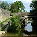
Lamberts Lane Bridge in Congleton, Cheshire
Bridge No 77 across the Macclesfield Canal is a turnover (or roving or snake) bridge which carries the towpath to the other side of the canal. Horses did not need to be unhitched from the boats when using these cunningly designed (and attractive) bridges.
Image: © Roger D Kidd
Taken: 9 Sep 2014
0.12 miles
4
Lamberts Lane Bridge in Congleton, Cheshire
Bridge No 77 across the Macclesfield Canal is a snake bridge (turnover bridge) which allowed horses on the towpath to cross to the other side of the canal without being unhitched from the boats.
Image: © Roger D Kidd
Taken: 4 Sep 2014
0.12 miles
5
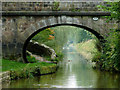
Macclesfield Canal near Congleton in Cheshire
Looking south-west through the arch of Lambert's Lane Bridge, No 77. It is a turnover bridge (roving bridge), cunningly designed to allow the horses to cross from one side of the canal to the other without being unhitched from their boats.
It carries Lambert's Lane, which is an unsurfaced bridleway off to the right, but has been incorporated into the housing estate off to the left.
Image: © Roger Kidd
Taken: 9 Sep 2014
0.12 miles
6
Snaily bridge
Engineered so that you don't need to unclip a horse when the tow path changes sides. I believe that these are unique to this area/canal.
Image: © Mike McCusker
Taken: 17 Oct 2009
0.12 miles
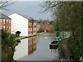
8
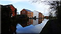
Apartments, Congleton Wharf, Macclesfield Canal
Image: © Colin Park
Taken: 16 Dec 2019
0.13 miles
9
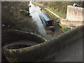
Characteristic roving bridge on Macclesfield Canal
This is Lamberts Lane Bridge, No.77 on the Macclesfield Canal near Congleton. These splendid spiral roving bridges are characteristic of this canal and allowed the towpath to change from one bank to the other without the need to unhitch the tow rope from the towing horse.
Image: © Jerry Evans
Taken: 1 Apr 2007
0.13 miles
10
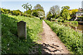
Macclesfield Canal Mile Stone (22 miles from Marple)
According to the canal society's website, these stones resembling grave markers are unique to the Macclesfield and Cromford canals. The Macclesfield's milestones had mostly been buried during the second world war as a precaution against enemy soldiers using them to find their way. All but three stones were dug up and re-erected by volunteers in the 1980s. This one, showing :-
From Marple 22 Miles (This Side)
From Hall Green 4¼ Mile (Other side)
Image: © Brian Deegan
Taken: 13 May 2023
0.13 miles