IMAGES TAKEN NEAR TO
Newton Place, CONGLETON, CW12 3EY
Introduction
This page details the photographs taken nearby to Newton Place, CW12 3EY by members of the Geograph project.
The Geograph project started in 2005 with the aim of publishing, organising and preserving representative images for every square kilometre of Great Britain, Ireland and the Isle of Man.

There are currently over 7.5m images from over14,400 individuals and you can help contribute to the project by visiting https://www.geograph.org.uk
Image Map
Images are licensed for reuse under creativecommons.org/licenses/by-sa/2.0
Notes
- Clicking on the map will re-center to the selected point.
- The higher the marker number, the further away the image location is from the centre of the postcode.
Image Listing (6 Images Found)
Images are licensed for reuse under creativecommons.org/licenses/by-sa/2.0
Image
Details
Distance
1
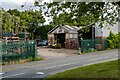
Belmont
Belmont steel fabricators in Congleton.
Image: © Peter McDermott
Taken: 13 Jul 2023
0.16 miles
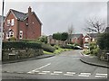
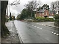
2
Park Lane A527 at junction with Highcroft Avenue, Congleton
Image: © Jonathan Hutchins
Taken: 18 Mar 2017
0.19 miles
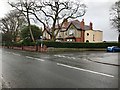
3
Park Lane A527 at junction with Copthorne Close, Congleton
Image: © Jonathan Hutchins
Taken: 18 Mar 2017
0.21 miles
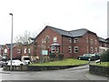
4
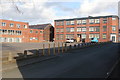
Edward Mill, Congleton
The building right and centre is Edward Mill. A silk processing mill of 1924 that replaced an earlier mill on this site and is now apartments. On the left is part of Beresford Mill, a large silk ribbon mill of the early 20th century.
Image: © Chris Allen
Taken: 17 Feb 2019
0.22 miles