IMAGES TAKEN NEAR TO
Dale Place, CONGLETON, CW12 3EB
Introduction
This page details the photographs taken nearby to Dale Place, CW12 3EB by members of the Geograph project.
The Geograph project started in 2005 with the aim of publishing, organising and preserving representative images for every square kilometre of Great Britain, Ireland and the Isle of Man.

There are currently over 7.5m images from over14,400 individuals and you can help contribute to the project by visiting https://www.geograph.org.uk
Image Map
Images are licensed for reuse under creativecommons.org/licenses/by-sa/2.0
Notes
- Clicking on the map will re-center to the selected point.
- The higher the marker number, the further away the image location is from the centre of the postcode.
Image Listing (4 Images Found)
Images are licensed for reuse under creativecommons.org/licenses/by-sa/2.0
Image
Details
Distance
1
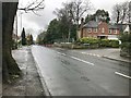
Park Lane A527 at junction with Copthorne Close, Congleton
Image: © Jonathan Hutchins
Taken: 18 Mar 2017
0.22 miles
2
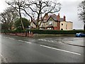
Park Lane A527 at junction with Highcroft Avenue, Congleton
Image: © Jonathan Hutchins
Taken: 18 Mar 2017
0.23 miles
3
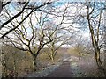
Biddulph Valley Way
Looking north along the embankment between the Timbers Brook (right) and Dane-in-Shaw Brook (left).
Image: © Stephen Craven
Taken: 29 Dec 2014
0.23 miles
4
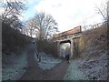
Bridge over the Biddulph Valley Way
This bridge carries Brookhouse Lane, and has at some time been strengthened by the addition of a concrete "inner liner". The narrowing of the opening probably puts paid to any idea of reopening this railway line.
Image: © Stephen Craven
Taken: 29 Dec 2014
0.25 miles