IMAGES TAKEN NEAR TO
The Parklands, CONGLETON, CW12 3DS
Introduction
This page details the photographs taken nearby to The Parklands, CW12 3DS by members of the Geograph project.
The Geograph project started in 2005 with the aim of publishing, organising and preserving representative images for every square kilometre of Great Britain, Ireland and the Isle of Man.

There are currently over 7.5m images from over14,400 individuals and you can help contribute to the project by visiting https://www.geograph.org.uk
Image Map
Images are licensed for reuse under creativecommons.org/licenses/by-sa/2.0
Notes
- Clicking on the map will re-center to the selected point.
- The higher the marker number, the further away the image location is from the centre of the postcode.
Image Listing (75 Images Found)
Images are licensed for reuse under creativecommons.org/licenses/by-sa/2.0
Image
Details
Distance
1
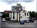
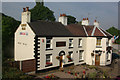
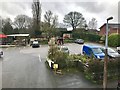
Queens Head, Congleton
The canal aspect and a ray of sunshine would do more justice to this interesting pub opposite the rail station. The beer range, up to seven real beers, makes this a must visit pub for boaters and others alike.
Image: © al partington
Taken: 23 May 2007
0.15 miles
2
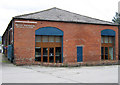
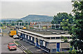
Wharf Bathroom Design Centre
Situated beside the road leading to the Image For more information see their website at http://www.wharfbathroomdesign.co.uk/ .
Image: © Jonathan Kington
Taken: 13 Jul 2010
0.15 miles
3
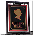
Sign for the Queens Head
This is the sign for the Image It is a very popular name for a public house and the sign often carries a silhouette of a head which could refer to number of different queens, but, due to an unwritten rule, it will never be the likeness of the current reigning monarch.
Image: © Jonathan Kington
Taken: 15 Dec 2010
0.15 miles
4
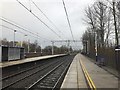
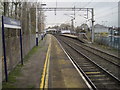
Looking north-east at Congleton railway station
Image: © Jonathan Hutchins
Taken: 18 Mar 2017
0.17 miles
5
The Queen's Head, Congleton
This pub is conveniently placed for both the Macclesfield Canal and Congleton's railway station in the Hightown district.
Image: © Stephen McKay
Taken: 2 Sep 2010
0.17 miles
6
Congleton Station
View NE, towards Macclesfield and Manchester; ex-North Stafford Stoke-on-Trent - Macclesfield - Manchester main line. The Cloud (1,115 ft.) prominent in distance.
Image: © Ben Brooksbank
Taken: 9 Jul 1986
0.17 miles
7
Entrance to Congleton Station
This is looking at the front of Congleton Station, from here the next stop to the left of the picture is Macclesfield, and Kidsgrove to the right. For another view of the station taken in 1986 see Ben Brooksbank's picture Image, apart from there being bushes in the borders and lines having been drawn in the car park there is very little change over the last 24 years.
Image: © Jonathan Kington
Taken: 13 Jul 2010
0.18 miles
8
Congleton railway station, Staffordshire
Opened in 1848 by the North Staffordshire Railway on the line from Stoke-on-Trent to Macclesfield.
View south west towards Kidsgrove and Stoke. The former goods shed, right, was in use for new owners when this image was taken.
Image: © Nigel Thompson
Taken: 15 Nov 2014
0.18 miles
10
The railway station glimpsed through the trees
In trying to replicate Ben Brooksbank's location when he took Image in 1986, I found that a lot of the trees had grown up in 24 years and this was the closest I could get and still see at least some of the station building. I would estimate his position as being somewhere between this picture and Image
Image: © Jonathan Kington
Taken: 13 Jul 2010
0.18 miles