IMAGES TAKEN NEAR TO
Burslam Street, CONGLETON, CW12 3AF
Introduction
This page details the photographs taken nearby to Burslam Street, CW12 3AF by members of the Geograph project.
The Geograph project started in 2005 with the aim of publishing, organising and preserving representative images for every square kilometre of Great Britain, Ireland and the Isle of Man.

There are currently over 7.5m images from over14,400 individuals and you can help contribute to the project by visiting https://www.geograph.org.uk
Image Map
Images are licensed for reuse under creativecommons.org/licenses/by-sa/2.0
Notes
- Clicking on the map will re-center to the selected point.
- The higher the marker number, the further away the image location is from the centre of the postcode.
Image Listing (75 Images Found)
Images are licensed for reuse under creativecommons.org/licenses/by-sa/2.0
Image
Details
Distance
1
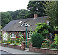
Attractive Cottage, Congleton, Cheshire
In Canal Street.
Image: © Roger D Kidd
Taken: 28 Aug 2007
0.04 miles
2
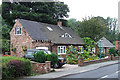
Attractive Cottage, Congleton, Cheshire
Image: © Roger D Kidd
Taken: 28 Aug 2007
0.05 miles
3
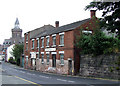
Old Buildings, Canal Street, Congleton, Cheshire
Image: © Roger D Kidd
Taken: 28 Aug 2007
0.07 miles
4
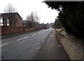
Looking down Canal Road
Looking towards the bottom of Canal Road, at the corner in the distance it becomes Canal Street.
Image: © Jonathan Kington
Taken: 15 Dec 2010
0.09 miles
6
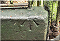
Benchmark by the south gate
This pivot mark is cut into the wall on the left side of the Image For more information on this and other marks see http://www.bench-marks.org.uk/bm36043 .
A pivot mark differs from a normal cut mark type of bench mark in that it does not have the horizontal bar above the arrow, instead a small hollow is carved out of the flat surface of the stone. A 5/8" (16mm) diameter ball bearing, or pivot, would be placed in the hole and the levelling staff placed on top. They would normally be made where the stone was too soft or brittle to accept a rivet without breaking.
Image: © Jonathan Kington
Taken: 17 Nov 2010
0.15 miles
7
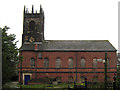
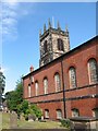
St Peter's Church, Congleton
Viewed from the south, St Peter's is an unusual looking, Grade I Listed ( http://www.britishlistedbuildings.co.uk/en-55863-church-of-st-peter-congleton ) church. Originally built in the 14th century as a timber framed building it was rebuilt in the mid-18th century when it was found to be decaying. The lower part of the original tower was retained while the main body was built in brick with stone facings ( http://en.wikipedia.org/wiki/St_Peter%27s_Church,_Congleton ).
Image: © Jonathan Kington
Taken: 17 Nov 2010
0.15 miles
8
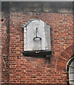
Sundial on St Peter's Church
This sundial, dated 1809, is mounted high on the south face of the church. St Peter's is an unusual looking, Grade I Listed ( http://www.britishlistedbuildings.co.uk/en-55863-church-of-st-peter-congleton ) church. Originally built in the 14th century as a timber framed building it was rebuilt in the mid-18th century when it was found to be decaying. The lower part of the original tower was retained while the main body was built in brick with stone facings ( http://en.wikipedia.org/wiki/St_Peter%27s_Church,_Congleton ). See also Image for a wider view of its location.
Image: © Jonathan Kington
Taken: 17 Nov 2010
0.15 miles
9
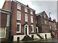
33 Lawton Street, Congleton
Grade II listed late eighteenth-century house.
List entry: https://historicengland.org.uk/listing/the-list/list-entry/1130466
Image: © Jonathan Hutchins
Taken: 18 Mar 2017
0.15 miles
10
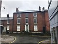
23 Lawton Street, Congleton
Grade II listed late eighteenth-century house.
List entry: https://www.historicengland.org.uk/listing/the-list/list-entry/1104893
Image: © Jonathan Hutchins
Taken: 18 Mar 2017
0.15 miles