IMAGES TAKEN NEAR TO
George Avenue, CW12 2QE
Introduction
This page details the photographs taken nearby to George Avenue, CW12 2QE by members of the Geograph project.
The Geograph project started in 2005 with the aim of publishing, organising and preserving representative images for every square kilometre of Great Britain, Ireland and the Isle of Man.

There are currently over 7.5m images from over14,400 individuals and you can help contribute to the project by visiting https://www.geograph.org.uk
Image Map
Images are licensed for reuse under creativecommons.org/licenses/by-sa/2.0
Notes
- Clicking on the map will re-center to the selected point.
- The higher the marker number, the further away the image location is from the centre of the postcode.
Image Listing (17 Images Found)
Images are licensed for reuse under creativecommons.org/licenses/by-sa/2.0
Image
Details
Distance
1
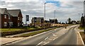
Buxton Road
New housing development alongside Buxton Road in Congleton.
Image: © Peter McDermott
Taken: 6 Mar 2021
0.07 miles
3
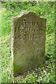
Old Milemarker by the Macclesfield Canal at Buglawton
Milemarker by the Macclesfield Canal, in parish of Congleton (Congleton District), South East of bridge 68, the A54 Buxton Road.
Inscription reads:-
: From / Marple / 20 Miles : : From / Hall Green / 6¼ Miles :
Grade II listed.
List Entry Number: 1237540 https://historicengland.org.uk/listing/the-list/list-entry/1237540
Surveyed
Milestone Society National ID: MAC-20
Image: © Milestone Society
Taken: Unknown
0.09 miles
4
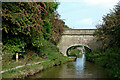
Wallworth's Bridge near Buglawton, Cheshire
Bridge No 69 across the Macclesfield Canal is an accommodation bridge linking fields, and carries no public way.
Note: The 1:50,000 map shown on the photo page has missed off this bridge.
Image: © Roger D Kidd
Taken: 4 Sep 2014
0.10 miles
5
Macclesfield Canal: Wallworths Bridge No 69
Image: © Dr Neil Clifton
Taken: 1 Apr 2015
0.10 miles
6
Wallworths Bridge near Congleton in Cheshire
Wallworths Bridge is No 69 across the Macclesfield Canal near Buglawton, Congleton. It is a farmer's accommodation bridge with no public right of way across it or into adjacent fields. It is missing from the OS map showing on this web page.
As I write in 2021, aerial photography shows that the farmland off to the left (Hudson Meadows) is being developed with housing.
Image: © Roger Kidd
Taken: 9 Sep 2014
0.10 miles
7
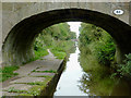
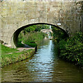
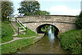
Wallworth's Bridge near Buglawton, Cheshire
Bridge No 69 across the Macclesfield Canal is an accommodation bridge linking fields, and carries no public way. I've got just in the right position with this one - to see the next bridge through the centre of the arch!
Note: The 1:50,000 map shown on the photo page has missed off this bridge.
Image: © Roger D Kidd
Taken: 4 Sep 2014
0.10 miles
8
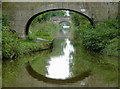
Wallworths Bridge near Congleton in Cheshire
Looking north-north-west, Wallworths Bridge is No 69 across the Macclesfield Canal near Buglawton, Congleton. It is a farmer's accommodation bridge with no public right of way across it or into adjacent fields. It is missing from the OS map showing on this web page.
As I write in 2021, aerial photography shows that the farmland off to the left (Hudson Meadows) is being developed with housing. https://bloorhomes.com/developments/cheshire/congleton/hudson-meadows
Image: © Roger Kidd
Taken: 9 Sep 2014
0.11 miles
9
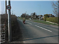
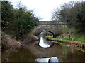
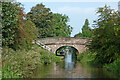
Buxton Road Bridge near Congleton, Cheshire
Looking north-north-east, Buxton Road Bridge is No 68 across the Macclesfield Canal and carries the A54 road.
Image: © Roger Kidd
Taken: 9 Sep 2014
0.11 miles
10
Buxton Road Bridge near Congleton, Cheshire
Looking north-north-east near Buglawton, Buxton Road Bridge is No 68 across the Macclesfield Canal and carries the A54 road.
Image: © Roger Kidd
Taken: 9 Sep 2014
0.11 miles