IMAGES TAKEN NEAR TO
Rode Green, CONGLETON, CW12 2NU
Introduction
This page details the photographs taken nearby to Rode Green, CW12 2NU by members of the Geograph project.
The Geograph project started in 2005 with the aim of publishing, organising and preserving representative images for every square kilometre of Great Britain, Ireland and the Isle of Man.

There are currently over 7.5m images from over14,400 individuals and you can help contribute to the project by visiting https://www.geograph.org.uk
Image Map
Images are licensed for reuse under creativecommons.org/licenses/by-sa/2.0
Notes
- Clicking on the map will re-center to the selected point.
- The higher the marker number, the further away the image location is from the centre of the postcode.
Image Listing (13 Images Found)
Images are licensed for reuse under creativecommons.org/licenses/by-sa/2.0
Image
Details
Distance
2
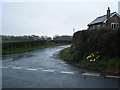
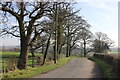
Shellow Lane/Pexall Road junction, Gawsworth
Pexall Lane goes left here before the lower signpost on the right proclaims entry into Gawsworth Parish - the boundary runs down Shellow Lane from the junction.
Image: © Peter Turner
Taken: 1 Mar 2012
0.01 miles
3
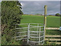
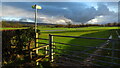
Kissing gate at junction Shellow Lane & Pexall Rd near Gawsworth
Image: © Colin Park
Taken: 22 Oct 2015
0.02 miles
4
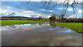
Flooded field by Shellow Lane, Gawsworth
Image: © Colin Park
Taken: 10 Dec 2021
0.06 miles
6
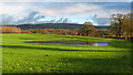
Flooded field by Shellow Lane, Gawsworth
Image: © Colin Park
Taken: 10 Dec 2021
0.08 miles
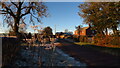
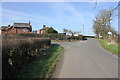
8
Shellow Lane at Clover Bank Organic Farm entrance
Image: © Peter Turner
Taken: 1 Mar 2012
0.09 miles
9
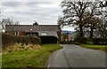
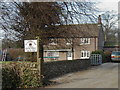
Rodegreen
Rodegreen Farm on Pexall Road.
Image: © Peter McDermott
Taken: 6 Mar 2021
0.11 miles