IMAGES TAKEN NEAR TO
Rood Hill, CONGLETON, CW12 1YZ
Introduction
This page details the photographs taken nearby to Rood Hill, CW12 1YZ by members of the Geograph project.
The Geograph project started in 2005 with the aim of publishing, organising and preserving representative images for every square kilometre of Great Britain, Ireland and the Isle of Man.

There are currently over 7.5m images from over14,400 individuals and you can help contribute to the project by visiting https://www.geograph.org.uk
Image Map
Images are licensed for reuse under creativecommons.org/licenses/by-sa/2.0
Notes
- Clicking on the map will re-center to the selected point.
- The higher the marker number, the further away the image location is from the centre of the postcode.
Image Listing (66 Images Found)
Images are licensed for reuse under creativecommons.org/licenses/by-sa/2.0
Image
Details
Distance
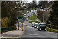
1
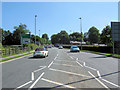
Looking up Clayton By-pass
Looking towards the traffic lights at the junction of Clayton By-pass (A34), Rood Hill and Rood Lane. Taken from the traffic island near the roundabout.
Image: © Jonathan Kington
Taken: 16 Jun 2010
0.05 miles
2
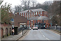
Rood Lane, Congleton
The junction of the A34 and A54. Centre-shot was the location of the 1930s "lighthouse", which warned nighttime motorists of this dangerous hill bend.
Image: © Adrian Bailey
Taken: 16 Feb 2005
0.07 miles
3
The junction of the A54 with the A34
The road is climbing out of the town away from the River Dane valley.
Image: © Bill Boaden
Taken: 9 Aug 2012
0.08 miles
4
Salford Mill, Congleton
Early 19th century silk mill overlooking the River Dane with a central pediment and clock. Now owned by a furnishing company. The wall on the left that incorporates window sills is the demolished Dane Bridge Mill. The bridge over the river is in the foreground. The Mill Chippy is evocative but I've no idea of the quality of the produce.
Image: © Chris Allen
Taken: 17 Feb 2019
0.10 miles
5
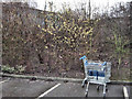
Catkins and trolleys
The Hazel catkins show that Spring is on its way to this Tesco's car-park, whereas the abandoned trolleys show how lazy some people can be. The trolley park is only a few metres away, but it was a very wet day.
Image: © Jonathan Kington
Taken: 26 Feb 2010
0.11 miles
6
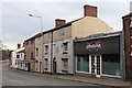
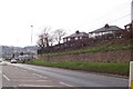
Silk Weavers' Cottage, Congleton
A row of three, three storey weavers' cottages with top storey multi-light loom shops. On Rood Hill by the junction with Royle Street. There are two collections of weavers' cottages within a few hundred yards in Congleton.
Image: © Chris Allen
Taken: 17 Feb 2019
0.11 miles
7
"Exciting changes" to Tesco's
The Image is extending by about one third again and it is hoped to be finished by Autumn 2010.
Image: © Jonathan Kington
Taken: 27 May 2010
0.12 miles
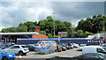
8
Instant woodland
The external work on the new extension to Tesco's Congleton store is nearly finished, and these semi-mature trees are waiting to be planted out to give the final touches.
Image: © Jonathan Kington
Taken: 25 Aug 2010
0.12 miles
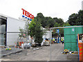
9
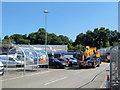
Tesco's changes are becoming visible
The framework for the new extension (see also Image and Image) to the Congleton Tesco store is now becoming visible. The mobile crane seemed to be waiting for space to enter the site.
Image: © Jonathan Kington
Taken: 16 Jun 2010
0.12 miles
10
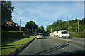
A34
A34 Clayton Bypass look towards Rood Hill in Congleton.
Image: © Peter McDermott
Taken: 6 Mar 2021
0.13 miles