IMAGES TAKEN NEAR TO
Bromley Road, CONGLETON, CW12 1PZ
Introduction
This page details the photographs taken nearby to Bromley Road, CW12 1PZ by members of the Geograph project.
The Geograph project started in 2005 with the aim of publishing, organising and preserving representative images for every square kilometre of Great Britain, Ireland and the Isle of Man.

There are currently over 7.5m images from over14,400 individuals and you can help contribute to the project by visiting https://www.geograph.org.uk
Image Map
Images are licensed for reuse under creativecommons.org/licenses/by-sa/2.0
Notes
- Clicking on the map will re-center to the selected point.
- The higher the marker number, the further away the image location is from the centre of the postcode.
Image Listing (10 Images Found)
Images are licensed for reuse under creativecommons.org/licenses/by-sa/2.0
Image
Details
Distance
1
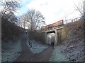
Bridge over the Biddulph Valley Way
This bridge carries Brookhouse Lane, and has at some time been strengthened by the addition of a concrete "inner liner". The narrowing of the opening probably puts paid to any idea of reopening this railway line.
Image: © Stephen Craven
Taken: 29 Dec 2014
0.14 miles
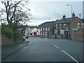
2
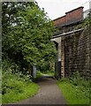
Biddulph Valley Way
Brookhouse Lane crossing the Biddulph Valley Way.
Image: © Peter McDermott
Taken: 13 Jul 2023
0.14 miles
3
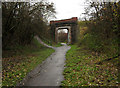
Bromley Road bridge
This very square bridge carries Bromley Road over the Biddulph Valley Way, it is also the exit point for the National Cycle Network route 55.
Image: © Jonathan Kington
Taken: 17 Nov 2010
0.14 miles
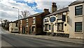
4
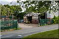
Belmont
Belmont steel fabricators in Congleton.
Image: © Peter McDermott
Taken: 13 Jul 2023
0.15 miles
5
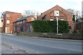
Dane Shaw Mill, Buglawton
Early 19th century silk mill next to Dane in Shaw Brook. The three storey building on the left is a former engine house. The site had a rather shut down look about it.
Image: © Chris Allen
Taken: 17 Feb 2019
0.18 miles
7
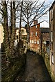
Dane in Shaw Brook
Dane in Shaw Brook in Congleton.
Image: © Peter McDermott
Taken: 6 Mar 2021
0.20 miles
9
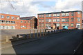
Edward Mill, Congleton
The building right and centre is Edward Mill. A silk processing mill of 1924 that replaced an earlier mill on this site and is now apartments. On the left is part of Beresford Mill, a large silk ribbon mill of the early 20th century.
Image: © Chris Allen
Taken: 17 Feb 2019
0.23 miles
10
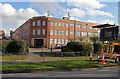
Beresford Mill, Congleton
A large silk ribbon mill of the early 20th century. Behind are a long range of single storey weaving sheds.
Image: © Chris Allen
Taken: 17 Feb 2019
0.24 miles