IMAGES TAKEN NEAR TO
Norbury Drive, CONGLETON, CW12 1NB
Introduction
This page details the photographs taken nearby to Norbury Drive, CW12 1NB by members of the Geograph project.
The Geograph project started in 2005 with the aim of publishing, organising and preserving representative images for every square kilometre of Great Britain, Ireland and the Isle of Man.

There are currently over 7.5m images from over14,400 individuals and you can help contribute to the project by visiting https://www.geograph.org.uk
Image Map
Images are licensed for reuse under creativecommons.org/licenses/by-sa/2.0
Notes
- Clicking on the map will re-center to the selected point.
- The higher the marker number, the further away the image location is from the centre of the postcode.
Image Listing (31 Images Found)
Images are licensed for reuse under creativecommons.org/licenses/by-sa/2.0
Image
Details
Distance
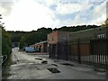
1
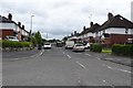
Norbury Drive, Lower Heath
Taken from Rood Lane (A34).
Image: © Trevor Harris
Taken: 28 Jul 2017
0.03 miles
3
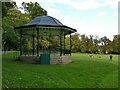
Bandstand in Congleton park
The bandstand was added in 1914, sadly the end of the Belle Epoque in which public performances flourished. However it is still used for occasional performances.
Image: © Stephen Craven
Taken: 15 Oct 2022
0.14 miles
4

Rugby match in Congleton park (1)
The park has fewer sporting facilities than most town parks, but the central grassed area is used for rugby in the winter (and maybe cricket in summer?).
Image: © Stephen Craven
Taken: 15 Oct 2022
0.16 miles
5

Rugby match in Congleton park (2)
The park has fewer sporting facilities than most town parks, but the central grassed area is used for rugby in the winter (and maybe cricket in summer?).
Image: © Stephen Craven
Taken: 15 Oct 2022
0.16 miles
6

Chestnut walk in Congleton park
Part of the perimeter path alongside the river.
Image: © Stephen Craven
Taken: 15 Oct 2022
0.16 miles
7
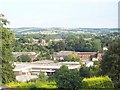
Industry in the Dane Valley
Looking SE from Lower Heath across to Buglawton and beyond.
Image: © Adrian Bailey
Taken: 30 Aug 2005
0.17 miles
9

Knot garden in Congleton park
Part of the Queen Elizabeth Garden in 1953.
Image: © Stephen Craven
Taken: 15 Oct 2022
0.18 miles
10
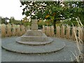
Remains of the market cross in Congleton park
From local history websites, the original market cross dated from c.1500 but was destroyed in 1772. Remaining stones from it were found in 1902, displayed outside the Town Hall, and moved here as part of the Queen Elizabeth Garden in 1953.
Image: © Stephen Craven
Taken: 15 Oct 2022
0.19 miles