IMAGES TAKEN NEAR TO
Rood Hill, CONGLETON, CW12 1NA
Introduction
This page details the photographs taken nearby to Rood Hill, CW12 1NA by members of the Geograph project.
The Geograph project started in 2005 with the aim of publishing, organising and preserving representative images for every square kilometre of Great Britain, Ireland and the Isle of Man.

There are currently over 7.5m images from over14,400 individuals and you can help contribute to the project by visiting https://www.geograph.org.uk
Image Map
Images are licensed for reuse under creativecommons.org/licenses/by-sa/2.0
Notes
- Clicking on the map will re-center to the selected point.
- The higher the marker number, the further away the image location is from the centre of the postcode.
Image Listing (46 Images Found)
Images are licensed for reuse under creativecommons.org/licenses/by-sa/2.0
Image
Details
Distance
2
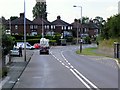
Norbury Drive, Lower Heath
Taken from Rood Lane (A34).
Image: © Trevor Harris
Taken: 28 Jul 2017
0.08 miles
3
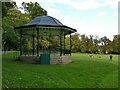
Bandstand in Congleton park
The bandstand was added in 1914, sadly the end of the Belle Epoque in which public performances flourished. However it is still used for occasional performances.
Image: © Stephen Craven
Taken: 15 Oct 2022
0.17 miles
4

Rugby match in Congleton park (2)
The park has fewer sporting facilities than most town parks, but the central grassed area is used for rugby in the winter (and maybe cricket in summer?).
Image: © Stephen Craven
Taken: 15 Oct 2022
0.19 miles
5
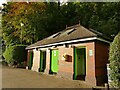
Public toilets in Congleton Park
Note the defbirillator on the wall.
Image: © Stephen Craven
Taken: 15 Oct 2022
0.19 miles
6

Knot garden in Congleton park
Part of the Queen Elizabeth Garden in 1953.
Image: © Stephen Craven
Taken: 15 Oct 2022
0.20 miles
7
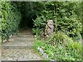
Wooden sculpture in Congleton park
At the foot of the steps into Town Wood is this sculpture, probably intended to be a bear (the town's symbol).
Image: © Stephen Craven
Taken: 15 Oct 2022
0.20 miles
8
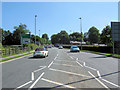
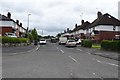
Looking up Clayton By-pass
Looking towards the traffic lights at the junction of Clayton By-pass (A34), Rood Hill and Rood Lane. Taken from the traffic island near the roundabout.
Image: © Jonathan Kington
Taken: 16 Jun 2010
0.20 miles
9
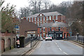
Salford Mill, Congleton
Early 19th century silk mill overlooking the River Dane with a central pediment and clock. Now owned by a furnishing company. The wall on the left that incorporates window sills is the demolished Dane Bridge Mill. The bridge over the river is in the foreground. The Mill Chippy is evocative but I've no idea of the quality of the produce.
Image: © Chris Allen
Taken: 17 Feb 2019
0.20 miles
10
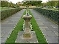
Sundial in Congleton park
The sundial was given to the park in 1929 but later incorporated in the Queen Elizabeth Garden, see Image
Image: © Stephen Craven
Taken: 15 Oct 2022
0.20 miles