IMAGES TAKEN NEAR TO
Daisybank Drive, CONGLETON, CW12 1LS
Introduction
This page details the photographs taken nearby to Daisybank Drive, CW12 1LS by members of the Geograph project.
The Geograph project started in 2005 with the aim of publishing, organising and preserving representative images for every square kilometre of Great Britain, Ireland and the Isle of Man.

There are currently over 7.5m images from over14,400 individuals and you can help contribute to the project by visiting https://www.geograph.org.uk
Image Map
Images are licensed for reuse under creativecommons.org/licenses/by-sa/2.0
Notes
- Clicking on the map will re-center to the selected point.
- The higher the marker number, the further away the image location is from the centre of the postcode.
Image Listing (8 Images Found)
Images are licensed for reuse under creativecommons.org/licenses/by-sa/2.0
Image
Details
Distance
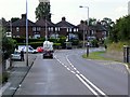
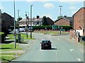
2
Norbury Drive, Lower Heath
Taken from Rood Lane (A34).
Image: © Trevor Harris
Taken: 28 Jul 2017
0.10 miles
3
Congleton Water Tower
Congleton Water Tower ( SJ860640 ) Viewed from Cheshire's Close (Mow)
Image: © Galatas
Taken: 27 May 2010
0.16 miles
4
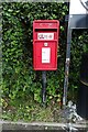
Elizabeth II postbox on Lower Heath, Congleton
Postbox No. CW12 42.
Image: © JThomas
Taken: 30 May 2024
0.17 miles
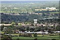
6

Industry in the Dane Valley
Looking SE from Lower Heath across to Buglawton and beyond.
Image: © Adrian Bailey
Taken: 30 Aug 2005
0.20 miles
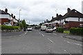
7
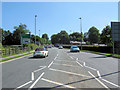
Looking up Clayton By-pass
Looking towards the traffic lights at the junction of Clayton By-pass (A34), Rood Hill and Rood Lane. Taken from the traffic island near the roundabout.
Image: © Jonathan Kington
Taken: 16 Jun 2010
0.23 miles
8
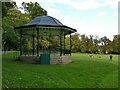
Bandstand in Congleton park
The bandstand was added in 1914, sadly the end of the Belle Epoque in which public performances flourished. However it is still used for occasional performances.
Image: © Stephen Craven
Taken: 15 Oct 2022
0.23 miles