IMAGES TAKEN NEAR TO
West Street, CONGLETON, CW12 1JP

Introduction

This page details the photographs taken nearby to West Street, CW12 1JP by members of the Geograph project.

The Geograph project started in 2005 with the aim of publishing, organising and preserving representative images for every square kilometre of Great Britain, Ireland and the Isle of Man.

There are currently over 7.5m images from over14,400 individuals and you can help contribute to the project by visiting https://www.geograph.org.uk

Image Map


Images are licensed for reuse under creativecommons.org/licenses/by-sa/2.0
Notes
  • Clicking on the map will re-center to the selected point.
  • The higher the marker number, the further away the image location is from the centre of the postcode.

Image Listing (101 Images Found)

Images are licensed for reuse under creativecommons.org/licenses/by-sa/2.0
  • ...
Image
Details
Distance
1
Small park on Antrobus Street
This lovely little formal garden appears to be open to the public.
Image: © Jonathan Kington Taken: 20 Mar 2011
0.03 miles
2
Antrobus Street car park, Congleton
A relatively cheap pay-and-display facility, handy for the town centre shops.
Image: © Stephen Craven Taken: 14 Aug 2021
0.05 miles
3
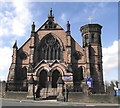
The United Reformed Church
The original church was built in 1790 and was located on Mill Street, where the Image now stands, it was rebuilt and replaced by this building on Antrobus Street in 1876. There is what appears to be a filled in bench mark at the base of the buttress adjoining the tower (Image).
Image: © Jonathan Kington Taken: 13 Mar 2011
0.05 miles
4
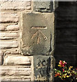
Filled-in bench mark
It looks as if this bench mark, on Image on Antrobus Street, was carefully filled with cement after finishing. There is no record of this cut mark on the Ordnance Survey database but there is a bench mark shown here on the 1909 map with a height of 295.84 ft (90.17m) above sea level. For more details on this and other nearby bench marks see http://www.bench-marks.org.uk/bm37368 .
Image: © Jonathan Kington Taken: 13 Mar 2011
0.05 miles
5
Bench mark on #10 West Street, Congleton
This cut mark is on the corner of the house visible in Image For more information on this and other bench marks see http://www.bench-marks.org.uk/bm36319 .
Image: © Jonathan Kington Taken: 15 Dec 2010
0.06 miles
6
Damian House, West Street, Congleton
An 18th century town house, grade II listed (list entry 1330316). It appears to have been converted into several apartments.
Image: © Stephen Craven Taken: 14 Aug 2021
0.06 miles
7
The Durham Ox
Located on the corner of Elizabeth Street and West Street, this pub is all boarded up and waiting for a buyer. It looks as if it has been on the market for some time, the big sign says the price has been reduced. For a close-up of the sign see Image
Image: © Jonathan Kington Taken: 20 Mar 2011
0.07 miles
8
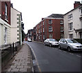
Along West Street
Looking along West Street towards Image and the top of Swan Bank. The first red-brick building on the right has a bench mark on the nearest corner (Image).
Image: © Jonathan Kington Taken: 15 Dec 2010
0.07 miles
9
Former stables at the Lion and Swan, Congleton
See Image for context. The stables building presumably belongs with the pub historically, but does not form part of the grade II listing.
Image: © Stephen Craven Taken: 14 Aug 2021
0.08 miles
10
The Lion and Swan, Congleton
The hotel was built in the 16th century and extended in later years.
Image: © David Weston Taken: 18 Aug 2013
0.08 miles
  • ...