IMAGES TAKEN NEAR TO
Belgrave Avenue, CONGLETON, CW12 1HT
Introduction
This page details the photographs taken nearby to Belgrave Avenue, CW12 1HT by members of the Geograph project.
The Geograph project started in 2005 with the aim of publishing, organising and preserving representative images for every square kilometre of Great Britain, Ireland and the Isle of Man.

There are currently over 7.5m images from over14,400 individuals and you can help contribute to the project by visiting https://www.geograph.org.uk
Image Map
Images are licensed for reuse under creativecommons.org/licenses/by-sa/2.0
Notes
- Clicking on the map will re-center to the selected point.
- The higher the marker number, the further away the image location is from the centre of the postcode.
Image Listing (95 Images Found)
Images are licensed for reuse under creativecommons.org/licenses/by-sa/2.0
Image
Details
Distance
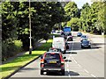
1
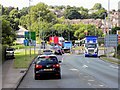
Looking up the A34
Looking towards the next roundabout at the junction of West Street and the A34 from the roundabout at the junction with Image The picture was taken from the traffic island at the bottom of Clayton By-pass.
Image: © Jonathan Kington
Taken: 16 Jun 2010
0.06 miles
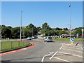
3
Roundabout on the A34 in Congleton
The roundabout provides access to Tesco and other retail and industrial units.
Image: © Bill Boaden
Taken: 9 Aug 2012
0.08 miles
4
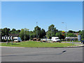
Roundabout on Clayton By-pass
This is the roundabout at the junction of the Clayton By-pass (A34) and Bank Road.
Image: © Jonathan Kington
Taken: 16 Jun 2010
0.09 miles
5
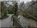
Path by the River Dane in Congleton
Image: © Jonathan Hutchins
Taken: 20 Jan 2019
0.09 miles
6
Emerging on to Dane Street, Congleton
Image: © Jonathan Hutchins
Taken: 20 Jan 2019
0.09 miles
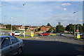
7
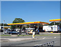
Shell garage
The Shell filling station by the junction of Clayton By-pass (A34) and Barn Road.
Image: © Jonathan Kington
Taken: 16 Jun 2010
0.11 miles
9
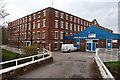
Dane Mill, Congleton
The modern extension spoils this somewhat. This is an early 19th century silk mill which was water powered from the river Dane. The central block is four storeys, 24 bays long with a central wheelhouse under the pedimented section. Now business units.
Image: © Chris Allen
Taken: 17 Feb 2019
0.13 miles
10
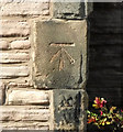
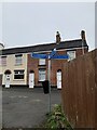
Filled-in bench mark
It looks as if this bench mark, on Image on Antrobus Street, was carefully filled with cement after finishing. There is no record of this cut mark on the Ordnance Survey database but there is a bench mark shown here on the 1909 map with a height of 295.84 ft (90.17m) above sea level. For more details on this and other nearby bench marks see http://www.bench-marks.org.uk/bm37368 .
Image: © Jonathan Kington
Taken: 13 Mar 2011
0.13 miles