IMAGES TAKEN NEAR TO
Park Street, CONGLETON, CW12 1EN
Introduction
This page details the photographs taken nearby to Park Street, CW12 1EN by members of the Geograph project.
The Geograph project started in 2005 with the aim of publishing, organising and preserving representative images for every square kilometre of Great Britain, Ireland and the Isle of Man.

There are currently over 7.5m images from over14,400 individuals and you can help contribute to the project by visiting https://www.geograph.org.uk
Image Map
Images are licensed for reuse under creativecommons.org/licenses/by-sa/2.0
Notes
- Clicking on the map will re-center to the selected point.
- The higher the marker number, the further away the image location is from the centre of the postcode.
Image Listing (114 Images Found)
Images are licensed for reuse under creativecommons.org/licenses/by-sa/2.0
Image
Details
Distance
1
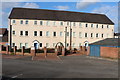
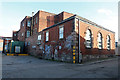
Park Mill, Congleton
A former silk mill built in 1825 by Charles Townley. Three storeys and 16 bays, brick built with a rendered front. Extensively rebuilt as accommodation in the late twentieth century. Although it has not been spoilt with balconies, you could be forgiven for not realising it was a nearly two hundred year old silk mill,
Image: © Chris Allen
Taken: 17 Feb 2019
0.00 miles
2
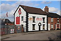
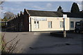
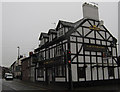
Congleton Rugby Club, Park Street
Although I was concentrating on Congleton's textile past, this pleasing building caught my eye and it was only decent to take its picture.
Image: © Chris Allen
Taken: 17 Feb 2019
0.02 miles
3
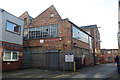
Lower Park Street Mills from Centenary Place, Congleton
Former silk mills.
Image: © Chris Allen
Taken: 17 Feb 2019
0.04 miles
4
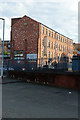
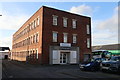
Victoria Mill, Foundry Bank, Congleton
Silk mill of 1858 with four storey, 12 bays long and originally steam powered. Cast iron columns support wooden floors internally. Now in other uses.
Image: © Chris Allen
Taken: 17 Feb 2019
0.05 miles
5
Spindle Street Mill, Congleton
Brick built silk mill of the mid-19th century. From 1924 used for fustian cutting and now in other use. At this western end it is claimed the engine house partly survives at ground floor level with stone window surrounds. I reckon it the part with three arch-headed windows. The lighting was problematic from this corner.
Image: © Chris Allen
Taken: 17 Feb 2019
0.05 miles
6
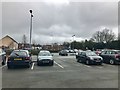
Back Park Street car park, Congleton
Image: © Jonathan Hutchins
Taken: 18 Mar 2017
0.06 miles
7
Victoria Mill, Congleton
The main part of the mill is a brick four storey block dating from 1858. This 13 bay, north-light weaving shed was a later addition. The mill was originally used for silk but is now in multiple occupancy.
Image: © Chris Allen
Taken: 17 Feb 2019
0.07 miles
8
Spindle Street Mill, Congleton
Brick built silk mill of the mid-19th century. From 1924 used for fustian cutting and now in other use. Apparently the engine and boiler house partly survive at ground floor level with stone window surrounds - I missed that.
Image: © Chris Allen
Taken: 17 Feb 2019
0.07 miles
9
The Antelope
Located at the top of Lawton Street in Congleton, this picture was taken looking across the very busy road junction near Mountbatten Way. For more information on the name and a close up of the sign see Image For another, similar view of see Image
Image: © Jonathan Kington
Taken: 17 Nov 2010
0.07 miles
10
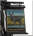
The sign for The Antelope
This is the sign for Image at the top of Lawton Street. Originally this animal would have been painted a little more flamboyantly, with a mane, a long tail and looking fawn-like so that they appeared more heraldic. More modern sign painters, however, prefer to depict them in a more natural stance. The antelope, and sometimes just the antelope's head, has long been associated with heraldry and appears in many coats of arms and emblems, including royal ones such as Henry V and Henry VI. My grateful thanks to Trish Steel ( http://www.geograph.org.uk/profile/9274 ) for her help in the research for this.
Image: © Jonathan Kington
Taken: 17 Nov 2010
0.07 miles