IMAGES TAKEN NEAR TO
Park View, Park Road, CONGLETON, CW12 1DR
Introduction
This page details the photographs taken nearby to Park View, Park Road, CW12 1DR by members of the Geograph project.
The Geograph project started in 2005 with the aim of publishing, organising and preserving representative images for every square kilometre of Great Britain, Ireland and the Isle of Man.

There are currently over 7.5m images from over14,400 individuals and you can help contribute to the project by visiting https://www.geograph.org.uk
Image Map
Images are licensed for reuse under creativecommons.org/licenses/by-sa/2.0
Notes
- Clicking on the map will re-center to the selected point.
- The higher the marker number, the further away the image location is from the centre of the postcode.
Image Listing (131 Images Found)
Images are licensed for reuse under creativecommons.org/licenses/by-sa/2.0
Image
Details
Distance
1
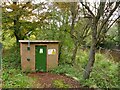
Flow recorder above Congleton Weir
The small building above the weir Image records river flow, probably by measuring the depth of flow over the smooth-edged straight weir, from which flow rate can be derived using a long-established empirical formula.
Image: © Stephen Craven
Taken: 15 Oct 2022
0.03 miles
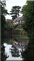
2
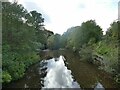
The Dane downstream of Congleton Park
A short distance downstream of the park is a weir, originally serving a silk mill (no longer extant) but now serving to retain the water level of the river through the park.
Image: © Stephen Craven
Taken: 15 Oct 2022
0.04 miles
3
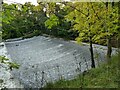
Congleton Weir
A large weir in sloping masonry and nearly 50 metres long, originally serving a silk mill (no longer extant) but now serving to retain the water level of the river through the park a short way upstream.
Image: © Stephen Craven
Taken: 15 Oct 2022
0.04 miles
4
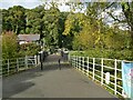
Bridge into Congleton Park
The bridge crosses the river Dane.
Image: © Stephen Craven
Taken: 15 Oct 2022
0.04 miles
5
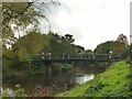
Park Road bridge into Congleton park
Park Road and this bridge at the end of it were laid out along with the development of the park itself in the 1860s to give access from the town centre.
Image: © Stephen Craven
Taken: 15 Oct 2022
0.04 miles
6
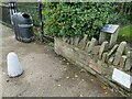
Benchmark in Congleton Park
The benchmark is on a larger stone within a low wall close to the river bridge. It isn't shown on any large scale map I have consulted. It may just have been used as a local benchmark for laying out the park, rather than part of the Ordnance Survey's national network.
Image: © Stephen Craven
Taken: 15 Oct 2022
0.05 miles
7
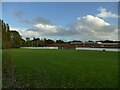
Hankinson's Field, Congleton
A recreation ground adjacent to the river Dane.
Image: © Stephen Craven
Taken: 15 Oct 2022
0.05 miles
8
Congleton - The R Dane beside Congleton Park
Image: © Colin Park
Taken: 7 Sep 2016
0.06 miles
9
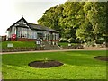
Pavilion in Congleton Park
The main pavilion, now a commercial cafe, was built in 1887 to mark the Golden Jubilee of Queen Victoria.
Image: © Stephen Craven
Taken: 15 Oct 2022
0.06 miles
10
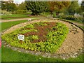
The 'community plaque' in Congleton park
Not a stone or metal plaque, but a flower bed. Its form is less easy to see in the autumn but it looks as if it forms the figure of a bear (the town's symbol).
Image: © Stephen Craven
Taken: 15 Oct 2022
0.06 miles