IMAGES TAKEN NEAR TO
Swan Bank, CONGLETON, CW12 1AH

Introduction

This page details the photographs taken nearby to Swan Bank, CW12 1AH by members of the Geograph project.

The Geograph project started in 2005 with the aim of publishing, organising and preserving representative images for every square kilometre of Great Britain, Ireland and the Isle of Man.

There are currently over 7.5m images from over14,400 individuals and you can help contribute to the project by visiting https://www.geograph.org.uk

Image Map


Images are licensed for reuse under creativecommons.org/licenses/by-sa/2.0
Notes
  • Clicking on the map will re-center to the selected point.
  • The higher the marker number, the further away the image location is from the centre of the postcode.

Image Listing (144 Images Found)

Images are licensed for reuse under creativecommons.org/licenses/by-sa/2.0
  • ...
Image
Details
Distance
1
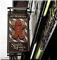
the Maskery
Please note that the lower case 't' in the title is intentional, it is mimicking the pub sign. Situated on Swan Bank, the Maskery is a Smith and Jones owned pub. For more information and a close up of the sign see Image
Image: © Jonathan Kington Taken: 17 Nov 2010
0.01 miles
2
Sign for the Maskery
The pub is owned by the Smith and Jones chain and is located on Swan Bank (Image). The name Maskery comes from the original owners of the building from 1831 to the 1950's who were bakers and confectioners well known for their gingerbread, hence the gingerbread man on the sign; during a royal visit to Congleton in 1913 a packet of gingerbread was presented to King George and Queen Mary. After this the premises became the first supermarket to open in Congleton, since when it has also traded as a DIY shop called Handi Cabin and latterly an Italian Restaurant. My grateful thanks to former Congleton resident Martin Tomlinson for the above information.
Image: © Jonathan Kington Taken: 17 Nov 2010
0.01 miles
3
The Counting House
A J D Wetherspoon pub and restaurant.
Image: © Colin Kinnear Taken: 3 Jun 2021
0.01 miles
4
The Counting House pub, Congleton
The pub, formerly the National Westminster Bank (hence the name), is grade II listed (list entry 1106298) but is not as old as the half-timbering may suggest, being of 19th century date. It is currently part of the J D Wetherspoon chain.
Image: © Stephen Craven Taken: 14 Aug 2021
0.01 miles
5
The Counting House
Built in the late 19th century, this Grade II listed ( http://www.britishlistedbuildings.co.uk/en-55921-national-westminster-bank-congleton ) Tudor style building used to be the premises for the National Westminster Bank (NatWest) and is now a J D Wetherspoon's Free House. Wetherspoon's have obviously played on the building's former status to produce its present name. It is located on Swan Bank opposite the end of Bridge Street, there is a bench mark on the corner by the arched gateway (Image). For a close-up of the sign see Image
Image: © Jonathan Kington Taken: 15 Dec 2010
0.02 miles
6
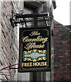
Sign for The Counting House
Image was formerly the premises for the National Westminster Bank, a status that J D Wetherspoon's have obviously used when they renamed it. The building was erected in the late 19th century in a Tudor style and is Grade II listed ( http://www.britishlistedbuildings.co.uk/en-55921-national-westminster-bank-congleton ).
Image: © Jonathan Kington Taken: 15 Dec 2010
0.02 miles
7
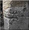
Bench mark on The Counting House
This cut mark is on the corner of Image, it looks very much like somebody has tried to destroy it. For more information on this and other bench marks go to http://www.bench-marks.org.uk/bm36318 .
Image: © Jonathan Kington Taken: 15 Dec 2010
0.02 miles
8
Footpath from Mill Street to Antrobus Street
The path connects the shopping streets with a car park.
Image: © Stephen Craven Taken: 14 Aug 2021
0.02 miles
9
The Lion and Swan, Congleton
The hotel was built in the 16th century and extended in later years.
Image: © David Weston Taken: 18 Aug 2013
0.02 miles
10
The Lion and Swan, Congleton
The side of the hotel, seen from West Street. The hotel was built in the 16th century and extended in later years.
Image: © David Weston Taken: 18 Aug 2013
0.02 miles
  • ...