IMAGES TAKEN NEAR TO
Cottons Lane, SANDBACH, CW11 4RB
Introduction
This page details the photographs taken nearby to Cottons Lane, CW11 4RB by members of the Geograph project.
The Geograph project started in 2005 with the aim of publishing, organising and preserving representative images for every square kilometre of Great Britain, Ireland and the Isle of Man.

There are currently over 7.5m images from over14,400 individuals and you can help contribute to the project by visiting https://www.geograph.org.uk
Image Map
Images are licensed for reuse under creativecommons.org/licenses/by-sa/2.0
Notes
- Clicking on the map will re-center to the selected point.
- The higher the marker number, the further away the image location is from the centre of the postcode.
Image Listing (124 Images Found)
Images are licensed for reuse under creativecommons.org/licenses/by-sa/2.0
Image
Details
Distance
1
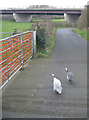
Guinea fowl on Cotton Lane
Cotton Lane is a public bridleway and no through road heading towards the Trent & Mersey Canal. The A534 passes overhead. A particularly stupid pair of guinea fowl just kept running ahead of the van.
Image: © Pauline E
Taken: 28 Feb 2012
0.01 miles
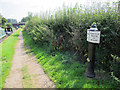
2
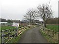
Cotton Lane, public bridleway
Passes under the A534 and leads to the Trent & Mersey Canal.
Image: © Pauline E
Taken: 28 Feb 2012
0.02 miles
3
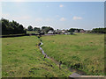
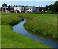
River Wheelock
Looking downstream from the canal towpath towards Wheelock village.
Image: © Stephen Craven
Taken: 26 Aug 2013
0.04 miles
4
Trent & Mersey Canal Milepost at Wheelock
Image: © Mat Fascione
Taken: 15 Jul 2015
0.05 miles
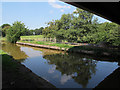
6
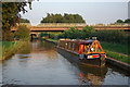
Trent & Mersey Canal, Wheelock
Just beyond the moored narrowboat is a modern bridge carrying the A534, Wheelock by-pass.
Image: © Stephen McKay
Taken: 2 Sep 2010
0.06 miles
8
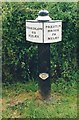
Old milemarker by the Trent & Mersey Canal, Wheelock
Milemarker by the Trent & Mersey Canal, in parish of Sandbach (Congleton District), Wheelock, East of wharf.
Inscription reads:-
: SHARDLOW / 69 / MILES : : PRESTON / BROOK / 23 / MILES :
Maker:-
: R&D / STONE / 1819 :
Grade II listed.
List Entry Number: 1130328 https://historicengland.org.uk/listing/the-list/list-entry/1130328
Surveyed
Milestone Society National ID: TMC-69
Image: © Milestone Society
Taken: Unknown
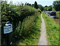
0.07 miles
9
Canal milepost near Wheelock
The milepost gives distances to Preston Brook (23 miles) and Shardlow (69 miles). It is listed grade 2 (list entry number 1130328).
Image: © Stephen Craven
Taken: 26 Aug 2013
0.07 miles
10
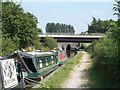
Road, canal, river
A complex bit of engineering here: in the foreground is the Trent and Mersey Canal; at this point it crosses the River Wheelock and a sewer pipe can be seen running alongside the canal. Then the Wheelock Bypass was built in the 1980s with presumably the minimum clearance required by the canal authority.
Image: © Stephen Craven
Taken: 26 Aug 2013
0.09 miles