IMAGES TAKEN NEAR TO
Hopol Drive, SANDBACH, CW11 4QN
Introduction
This page details the photographs taken nearby to Hopol Drive, CW11 4QN by members of the Geograph project.
The Geograph project started in 2005 with the aim of publishing, organising and preserving representative images for every square kilometre of Great Britain, Ireland and the Isle of Man.

There are currently over 7.5m images from over14,400 individuals and you can help contribute to the project by visiting https://www.geograph.org.uk
Image Map
Images are licensed for reuse under creativecommons.org/licenses/by-sa/2.0
Notes
- Clicking on the map will re-center to the selected point.
- The higher the marker number, the further away the image location is from the centre of the postcode.
Image Listing (109 Images Found)
Images are licensed for reuse under creativecommons.org/licenses/by-sa/2.0
Image
Details
Distance
1
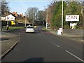
Wheelock - looking north from the canal bridge
Zan is not a mystic art, but rather a small industrial estate.
Image: © Peter Whatley
Taken: 21 Jan 2011
0.06 miles
2
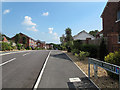
Meadowbank Avenue, Wheelock
Infill development at its most blatant. At the time of the photograph this development was so new (built c.2011) that online maps either did not show it at all, or still showed the pair of houses on Wheelock Road that had been demolished to make way for the access road into the field behind where several houses were built.
Image: © Stephen Craven
Taken: 26 Aug 2013
0.06 miles
3
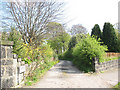
Zan Drive
The unusual name of this private road is a reference to the former Zan Mill - a fustian mill, whose name is perpetuated by the industrial park now on the site. History at http://www.squidoo.com/Wheelock#module10540359
Image: © Stephen Craven
Taken: 18 Apr 2009
0.07 miles
4
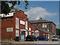
Zan Industrial Park, Wheelock
The main building is a former fustian mill. For more of its history see http://www.squidoo.com/Wheelock . It is now a mixture of light industrial units and offices of various companies.
Image: © Stephen Craven
Taken: 26 Aug 2013
0.07 miles
5
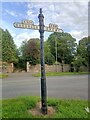
Direction Sign – Signpost on Crewe Road in Wheelock
Located in Wheelock, on the northwest side of the junction of the B5079 Hind Heath Road and Crewe Road, once the A534. Sandbach parish. 3 arms, 1 missing, and missing finial. See also https://www.geograph.org.uk/photo/6038381 and https://www.geograph.org.uk/photo/1263054 which show the missing third arm to Middlewich.
Milestone Society National ID: CH_SJ7459
Image: © N Upton
Taken: 1 Aug 2023
0.08 miles
6
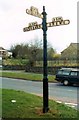
Old road sign in Wheelock
The main road in the picture is no longer the A534, a number now given to the Wheelock Bypass at this point, but unclassified. B5079 to Middlewich is still correct. The sign is outside the congregational church Image
Image: © Stephen Craven
Taken: 18 Apr 2009
0.08 miles
7
Entrance to Zan Business Park, Wheelock
Image: © Alexander P Kapp
Taken: 28 Jul 2011
0.08 miles
8

Zan Business Park, Wheelock, Clock
Image: © Alexander P Kapp
Taken: 28 Jul 2011
0.08 miles
9
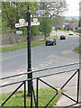
Old Direction Sign - Signpost by the former A534, Crewe Road, Wheelock
Lost finial - 3 arms; Cheshire CC post by the UC road (was A534), in parish of Sandbach (Congleton District), Crewe Road junction with B5079 Hind Heath Road, Wheelock.
Surveyed
Milestone Society National ID: CH_SJ7459.
Image: © Milestone Society
Taken: Unknown
0.08 miles
10
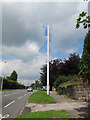
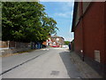
Vodafone mast on Crewe Road, Wheelock
The operator's name is given on the green cabinet on the pavement.
Image: © Stephen Craven
Taken: 26 Aug 2013
0.09 miles