IMAGES TAKEN NEAR TO
Mill Hill Drive, SANDBACH, CW11 4PW
Introduction
This page details the photographs taken nearby to Mill Hill Drive, CW11 4PW by members of the Geograph project.
The Geograph project started in 2005 with the aim of publishing, organising and preserving representative images for every square kilometre of Great Britain, Ireland and the Isle of Man.

There are currently over 7.5m images from over14,400 individuals and you can help contribute to the project by visiting https://www.geograph.org.uk
Image Map
Images are licensed for reuse under creativecommons.org/licenses/by-sa/2.0
Notes
- Clicking on the map will re-center to the selected point.
- The higher the marker number, the further away the image location is from the centre of the postcode.
Image Listing (20 Images Found)
Images are licensed for reuse under creativecommons.org/licenses/by-sa/2.0
Image
Details
Distance
1
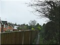
Footpath from Coronation Crescent to Mill Hill Lane
Old maps show that the footpath predates the housing estate.
Image: © Stephen Craven
Taken: 28 Dec 2021
0.01 miles
2
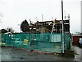
Construction on Mill Hill Lane
Clearly not a new property but I couldn't decide whether it was being demolished or just comprehensively refurbished including re-roofing.
Image: © Stephen Craven
Taken: 28 Dec 2021
0.03 miles
3
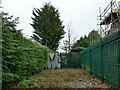
Small substation, Mill Hill Lane
An unusually small installation, with no protective building, though the size of the enclosure suggests that there may have been more substantial plant here at one time.
Image: © Stephen Craven
Taken: 28 Dec 2021
0.03 miles
4
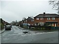
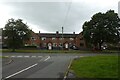
Latham Road, Sandbach
A side road off Coronation Crescent with post-War housing typical of this part of the town.
Image: © Stephen Craven
Taken: 28 Dec 2021
0.06 miles
5
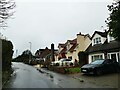
Houses on Mill Hill Lane
The houses here are individually designed and eclectic in style.
Image: © Stephen Craven
Taken: 28 Dec 2021
0.08 miles
6
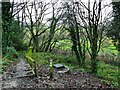
Steps into Brook Wood
Steps off Coronation Crescent leading to the Brook Wood Trail, which runs for 750m from here to the edge of the town centre. The manhole cover to the right is probably on a sewer leading to the pipe across the brook Image
Image: © Stephen Craven
Taken: 28 Dec 2021
0.08 miles
7
Third Avenue
Looking across Third Avenue from the end of Price Avenue.
Image: © DS Pugh
Taken: 5 Aug 2023
0.13 miles
8
Park Lane
Looking towards the junction with Crewe Road.
Image: © DS Pugh
Taken: 5 Aug 2023
0.14 miles
9
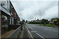
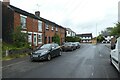
Crewe Road near Park Lane
Looking along Crewe Road in Sandbach near the junction with Park Lane.
Image: © DS Pugh
Taken: 5 Aug 2023
0.14 miles
10
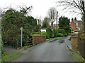
Mill Hill Lane bridge
The bridge crosses a small brook, known locally as Dingle Brook though on the OS map it is shown as 'mill stream' near this point (the old mill is to the right of the photographer). According to the website romanroads.org, "The bridge and lane at Sandbach Mill preserve the Roman line so the river crossing point here is almost 2000 years old." A public footpath leaves the road to the east of the bridge.
Image: © Stephen Craven
Taken: 28 Dec 2021
0.15 miles