IMAGES TAKEN NEAR TO
Cedar Close, SANDBACH, CW11 4JS
Introduction
This page details the photographs taken nearby to Cedar Close, CW11 4JS by members of the Geograph project.
The Geograph project started in 2005 with the aim of publishing, organising and preserving representative images for every square kilometre of Great Britain, Ireland and the Isle of Man.

There are currently over 7.5m images from over14,400 individuals and you can help contribute to the project by visiting https://www.geograph.org.uk
Image Map
Images are licensed for reuse under creativecommons.org/licenses/by-sa/2.0
Notes
- Clicking on the map will re-center to the selected point.
- The higher the marker number, the further away the image location is from the centre of the postcode.
Image Listing (43 Images Found)
Images are licensed for reuse under creativecommons.org/licenses/by-sa/2.0
Image
Details
Distance
1
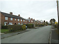
Stringer Avenue, Sandbach
A dead-end residential street off Hassall Road.
Image: © Stephen Craven
Taken: 19 Mar 2017
0.03 miles
2
Sandbach Cemetery: standard headstones
The majority of headstones in the cemetery are in a uniform black polished granite.
Image: © Stephen Craven
Taken: 19 Mar 2017
0.05 miles
3
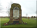
Sandbach Cemetery: Brunner Mond war memorial
The stone memorial was moved in 1934 from the Sandbach works of Brunner Mond. The company made sodium bicarbonate from salt brine, and continued in business until 2006, eventually becoming part of the Tata group.
According to Historic England, this memorial was one of several designed for the company by Thomas Arthur Darcy Braddell (1884-1970) at their sites in Silvertown, Winnington, Lostock, Sandbach and Middlewich, and the Mond Mausoleum at St Pancras and Islington Cemetery. Source: https://historicengland.org.uk/listing/the-list/list-entry/1452765?section=official-list-entry
Image: © Stephen Craven
Taken: 19 Mar 2017
0.06 miles
4
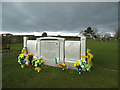
Sandbach Cemetery: Grave of P A Doherty
P A Doherty (1972-2015) has the most impressive monument of any in the cemetery. This being just after St Patrick's day the grave was decorated with Irish flags.
Image: © Stephen Craven
Taken: 19 Mar 2017
0.06 miles
5
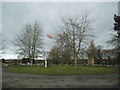
Sandbach Cemetery: Union flag
The flag flies over the roundabout at the centre of the cemetery.
Image: © Stephen Craven
Taken: 19 Mar 2017
0.06 miles
6
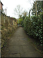
Footpath to Stringer Avenue
Stringer Avenue is a dead end at its western end, but this path links it to The Hill.
Image: © Stephen Craven
Taken: 19 Mar 2017
0.07 miles
7
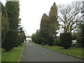
Sandbach Cemetery: drive
Looking outwards from the cemetery, down the drive towards The Hill.
Image: © Stephen Craven
Taken: 19 Mar 2017
0.07 miles
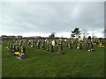
8
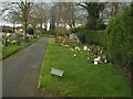
Sandbach Cemetery: Children's area
Always the saddest part of a cemetery, the graves of those who died young.
Image: © Stephen Craven
Taken: 19 Mar 2017
0.07 miles
9
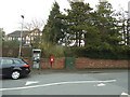
Phone box and post box, Hassall Road
Opposite the end of Stringer Avenue.
Image: © Stephen Craven
Taken: 19 Mar 2017
0.08 miles
10
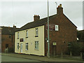
Griffiths and Booths, The Hill, Sandbach
A funeral director, not far from the town cemetery.
Image: © Stephen Craven
Taken: 19 Mar 2017
0.08 miles