IMAGES TAKEN NEAR TO
Smithfield Lane, SANDBACH, CW11 4JA
Introduction
This page details the photographs taken nearby to Smithfield Lane, CW11 4JA by members of the Geograph project.
The Geograph project started in 2005 with the aim of publishing, organising and preserving representative images for every square kilometre of Great Britain, Ireland and the Isle of Man.

There are currently over 7.5m images from over14,400 individuals and you can help contribute to the project by visiting https://www.geograph.org.uk
Image Map
Images are licensed for reuse under creativecommons.org/licenses/by-sa/2.0
Notes
- Clicking on the map will re-center to the selected point.
- The higher the marker number, the further away the image location is from the centre of the postcode.
Image Listing (84 Images Found)
Images are licensed for reuse under creativecommons.org/licenses/by-sa/2.0
Image
Details
Distance
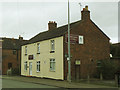
1
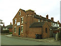
Austin Broady Associates, The Hill, Sandbach
A firm of ventilation engineers, occupying a property that looks as if it might have had an industrial past (was that a chimney?)
Image: © Stephen Craven
Taken: 19 Mar 2017
0.11 miles
3
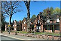
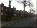
Sandbach Almshouses
In 1865, twenty Almshouses were built for the benefit of poor persons of good character resident in the ancient parish of Sandbach. Rules for occupation were strict. Residents had to attend church each Sunday and were not allowed to keep dogs or pigeons. Sir George Gilbert Scott designed the Almshouses and they cost £2,500 to build. They are listed Grade II.
Image: © Eirian Evans
Taken: 22 Apr 2021
0.11 miles
4
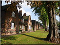
Almshouses, Newcastle Road
Like Sandbach School, Tall Chimneys (the Old Vicarage), the town's Literary Institution and Sandbach Heath C of E church, this row of Almshouses was the work of the prolific Victorian architect Sir George Gilbert Scott.
Image: © Chris Martyn
Taken: 9 Oct 2010
0.11 miles
5
Griffiths and Booths, The Hill, Sandbach
A funeral director, not far from the town cemetery.
Image: © Stephen Craven
Taken: 19 Mar 2017
0.11 miles
6
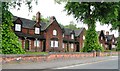
Almshouses - Newcastle Road, Sandbach
Image: © Anthony Parkes
Taken: 22 May 2014
0.12 miles
7
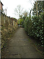
Footpath to Stringer Avenue
Stringer Avenue is a dead end at its western end, but this path links it to The Hill.
Image: © Stephen Craven
Taken: 19 Mar 2017
0.12 miles
8
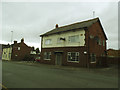
Former Sandpiper pub, The Hill, Sandbach
According to CAMRA's Whatpub website, the pub had closed by 2015. Asset of Community Value status was granted on 21 December 2015 but it looks as if thee community group failed to get enough backing for a takeover and the building is now up for let.
Image: © Stephen Craven
Taken: 19 Mar 2017
0.12 miles
9
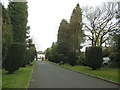
Sandbach Cemetery: drive
Looking outwards from the cemetery, down the drive towards The Hill.
Image: © Stephen Craven
Taken: 19 Mar 2017
0.13 miles
10
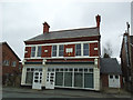
Former Co-Operative Store, The Hill, Sandbach
The building bears the date 1897 and the name of the Sandbach Industrial Co-Operative Society Ltd. It is currently vacant.
Image: © Stephen Craven
Taken: 19 Mar 2017
0.13 miles