IMAGES TAKEN NEAR TO
Hassall Road, SANDBACH, CW11 4HL
Introduction
This page details the photographs taken nearby to Hassall Road, CW11 4HL by members of the Geograph project.
The Geograph project started in 2005 with the aim of publishing, organising and preserving representative images for every square kilometre of Great Britain, Ireland and the Isle of Man.

There are currently over 7.5m images from over14,400 individuals and you can help contribute to the project by visiting https://www.geograph.org.uk
Image Map
Images are licensed for reuse under creativecommons.org/licenses/by-sa/2.0
Notes
- Clicking on the map will re-center to the selected point.
- The higher the marker number, the further away the image location is from the centre of the postcode.
Image Listing (4 Images Found)
Images are licensed for reuse under creativecommons.org/licenses/by-sa/2.0
Image
Details
Distance
1
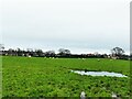
Sheep in a field off Houndings Lane
A very wet field, at that.
Image: © Stephen Craven
Taken: 28 Dec 2021
0.15 miles
2
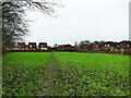
Footpath off Houndings Lane
The footpath is shown on old maps preceding the present housing estate, and the path retains its public right of way status (Sandbach FP38), but now just connects to Laurel Close, one of the side streets on the estate.
Image: © Stephen Craven
Taken: 28 Dec 2021
0.17 miles
3
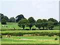
Cows near Malkins Bank
A view from the canal towpath across several fields.
Image: © Stephen Craven
Taken: 26 Aug 2013
0.21 miles
4
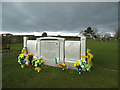
Sandbach Cemetery: Grave of P A Doherty
P A Doherty (1972-2015) has the most impressive monument of any in the cemetery. This being just after St Patrick's day the grave was decorated with Irish flags.
Image: © Stephen Craven
Taken: 19 Mar 2017
0.24 miles