IMAGES TAKEN NEAR TO
Flat Lane, SANDBACH, CW11 4BE
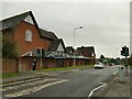
Introduction
This page details the photographs taken nearby to Flat Lane, CW11 4BE by members of the Geograph project.
The Geograph project started in 2005 with the aim of publishing, organising and preserving representative images for every square kilometre of Great Britain, Ireland and the Isle of Man.

There are currently over 7.5m images from over14,400 individuals and you can help contribute to the project by visiting https://www.geograph.org.uk
Image Map
Images are licensed for reuse under creativecommons.org/licenses/by-sa/2.0
Notes
- Clicking on the map will re-center to the selected point.
- The higher the marker number, the further away the image location is from the centre of the postcode.
Image Listing (366 Images Found)
Images are licensed for reuse under creativecommons.org/licenses/by-sa/2.0
Image
Details
Distance
1
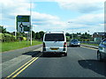
Defibrillator, Sandbach Waitrose
A community facility on the outside wall of the supermarket. See Image for context.
Image: © Stephen Craven
Taken: 10 Apr 2022
0.01 miles
2
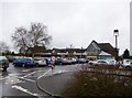
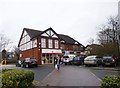
Sandbach, Waitrose
Supermarket on Old Mill Road.
Image: © Mike Faherty
Taken: 28 Dec 2012
0.02 miles
3
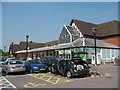
Waitrose supermarket, Sandbach
The supermarket was built as infill development at the same time as (or shortly after) the Sandbach inner relief road. It was originally Safeway, then Morrisons and finally Waitrose.
Image: © Stephen Craven
Taken: 26 Jun 2010
0.02 miles
4
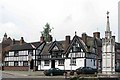
Sandbach
"Olde Worlde" buildings near the memorial in Sandbach
Image: © www fotodiscs4u co uk
Taken: 12 Nov 2006
0.02 miles
5
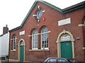
Chapel Street, Sandbach
Providence School 1859. Note the separate entrances for boys and girls.
Image: © Margaret Sutton
Taken: 19 Mar 2005
0.02 miles
6
Sandbach Post Office
With stationers, on St. George's Walk.
Image: © Mike Faherty
Taken: 28 Dec 2012
0.03 miles
7
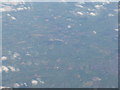
Elworth and Sandbach
Looking east across the Cheshire Plain; the northern outskirts of Crewe are at the right of the picture.
Image: © M J Richardson
Taken: 7 Oct 2010
0.04 miles
8
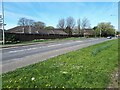
Pelican Crossing on Old Mill Road
The road was opened in 1986 as part of the Sandbach bypass, and is crossed at this point by the much older thoroughfare Flat Lane (now only an urban footpath). Beyond the crossing is the rear of Waitrose - see Image for the front.
Image: © Stephen Craven
Taken: 17 Oct 2021
0.04 miles
9
Old Mill Road, Sandbach
There were lots of daffodils on the far verge, though not very evident from this side of the road.
Image: © Stephen Craven
Taken: 10 Apr 2022
0.04 miles