IMAGES TAKEN NEAR TO
Dappled White Close, SANDBACH, CW11 4AJ
Introduction
This page details the photographs taken nearby to Dappled White Close, CW11 4AJ by members of the Geograph project.
The Geograph project started in 2005 with the aim of publishing, organising and preserving representative images for every square kilometre of Great Britain, Ireland and the Isle of Man.

There are currently over 7.5m images from over14,400 individuals and you can help contribute to the project by visiting https://www.geograph.org.uk
Image Map
Images are licensed for reuse under creativecommons.org/licenses/by-sa/2.0
Notes
- Clicking on the map will re-center to the selected point.
- The higher the marker number, the further away the image location is from the centre of the postcode.
Image Listing (73 Images Found)
Images are licensed for reuse under creativecommons.org/licenses/by-sa/2.0
Image
Details
Distance
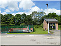
1
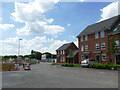
Holly Blue Road, Sandbach
This represents the end of Phase 1 of the J One Seven development, but Phase 2 is already in construction.
Note - location is estimated from the development site plan, as the road is too new to be shown on public maps yet.
Image: © Stephen Craven
Taken: 22 Jun 2019
0.03 miles
2
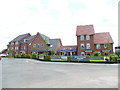
J One Seven show houses and information centre
I presume the eclectic style of these houses is to show the range of dwellings available on the estate when it is completed. Whether they remain as permanent construction, or get demolished and replaced with a more consistent set, remains to be seen.
Note - location is estimated from the development site plan, as the road is too new to be shown on public maps yet.
Image: © Stephen Craven
Taken: 22 Jun 2019
0.04 miles
3
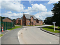
Comma Road, Sandbach
The road forms part of Phase 1 of the new J One Seven housing development (see shared description).
Image: © Stephen Craven
Taken: 22 Jun 2019
0.04 miles
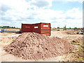
4
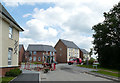
Roadworks on Comma Road
Housing was completed and occupied in this first phase of the J One Seven housing development, but road surfacing and other finishing touches were still in progress.
Note - location is estimated from the development site plan, as the road is too new to be shown on public maps yet.
Image: © Stephen Craven
Taken: 22 Jun 2019
0.05 miles
5
Sewage pumping station, Comma Road, Sandbach
The facility serves the new J One Seven housing development.
Image: © Stephen Craven
Taken: 22 Jun 2019
0.05 miles
6
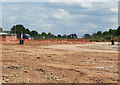
J One Seven Phase 2 under construction (1)
Looking roughly east, with the spire of St John's church, Sandbach Heath visible in the distance (about 700m away, the other side of the motorway).
Note - location is estimated from the development site plan.
Image: © Stephen Craven
Taken: 22 Jun 2019
0.05 miles
7
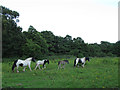
Family of horses
This family of horses walked the length of the field in front of us. It is not a very nice home for them Image
Image: © Stephen Craven
Taken: 22 Jul 2012
0.05 miles
8
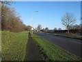
M16 Junction 17 rebuilding (1)
The approach along Sandbach Bypass (Old Mill Road, A534) from the south-west, before reconstruction work started.
Image: © Stephen Craven
Taken: 28 Dec 2014
0.06 miles
9
Stile into new housing development
Phase 1 of the new J One Seven housing development has been built on the alignment of the footpath east of the bypass, but existing stiles have been retained where it enters and leaves the site. See Image for the same view in 2012.
Image: © Stephen Craven
Taken: 22 Jun 2019
0.06 miles
10
J One Seven Phase 2 under construction (1)
Looking roughly north-east, with the motorway junction visible in the background.
Note - location is estimated from the development site plan.
Image: © Stephen Craven
Taken: 22 Jun 2019
0.06 miles