IMAGES TAKEN NEAR TO
Comma Road, SANDBACH, CW11 4AE
Introduction
This page details the photographs taken nearby to Comma Road, CW11 4AE by members of the Geograph project.
The Geograph project started in 2005 with the aim of publishing, organising and preserving representative images for every square kilometre of Great Britain, Ireland and the Isle of Man.

There are currently over 7.5m images from over14,400 individuals and you can help contribute to the project by visiting https://www.geograph.org.uk
Image Map
Images are licensed for reuse under creativecommons.org/licenses/by-sa/2.0
Notes
- Clicking on the map will re-center to the selected point.
- The higher the marker number, the further away the image location is from the centre of the postcode.
Image Listing (63 Images Found)
Images are licensed for reuse under creativecommons.org/licenses/by-sa/2.0
Image
Details
Distance
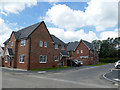
1
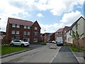
South end of Comma Road, Sandbach
Part of the new J One Seven housing development. This part of the site occupies land between the A534 and Offley Wood that was grazed by horses a few years ago Image
Note - location is estimated from the development site plan, as the road is too new to be shown on public maps yet.
Image: © Stephen Craven
Taken: 22 Jun 2019
0.01 miles
2
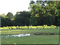
Geese and temporary pond
A gaggle of Canada geese next to a temporary pond formed by heavy rainfall earlier in the week.
Image: © Stephen Craven
Taken: 22 Jul 2012
0.02 miles
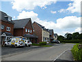
3
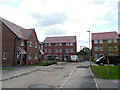
South-eastern corner of J One Seven, looking east
Part of the new J One Seven housing development. This short spur road is so new there is not even a name given for it on the site plan, or on the ground, yet.
Note - location is estimated from the development site plan, as the road is too new to be shown on public maps yet.
Image: © Stephen Craven
Taken: 22 Jun 2019
0.02 miles
4
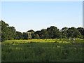
Field of ragwort
I was surprised to see horses in this field given the amount of ragwort growing in it. The trees beyond the field form part of Offley Wood, an ancient woodland, the rest of which was lost with the construction of the Sandbach bypass.
Image: © Stephen Craven
Taken: 22 Jul 2012
0.04 miles
5
Monarch Place, Sandbach
Part of the new J One Seven housing development. The road is named after a species of butterfly, not after the Queen.
Note - location is estimated from the development site plan, as the road is too new to be shown on public maps yet.
Image: © Stephen Craven
Taken: 22 Jun 2019
0.04 miles
6
South-eastern corner of J One Seven, looking west
Part of the new J One Seven housing development. This short spur road is so new there is not even a name given for it on the site plan, or on the ground, yet.
Note - location is estimated from the development site plan, as the road is too new to be shown on public maps yet.
Image: © Stephen Craven
Taken: 22 Jun 2019
0.05 miles
7
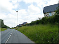
Shared use path alongside the Sandbach Bypass
Phase 1 of the new J One Seven housing development is seen to the right.
Image: © Stephen Craven
Taken: 22 Jun 2019
0.06 miles
8
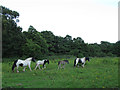
Family of horses
This family of horses walked the length of the field in front of us. It is not a very nice home for them Image
Image: © Stephen Craven
Taken: 22 Jul 2012
0.06 miles
9
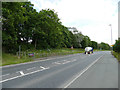
Pedestrian crossing of the Sandbach Bypass
The crossing only offers a safety barrier (on one side) and a refuge in the middle of the road for safety, with no traffic lights. The crossing follows an established right of way pre-dating the road. A milk tanker heads towards the M6 motorway.
Image: © Stephen Craven
Taken: 22 Jun 2019
0.07 miles
10
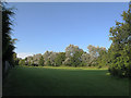
Open space behind the Parkhouse estate
A strip of green space was left between the housing and the A534 Sandbach Bypass (behind the trees to the right). I don't know whether it's technically a public open space but it appears to be used as such.
Image: © Stephen Craven
Taken: 22 Jul 2012
0.07 miles