IMAGES TAKEN NEAR TO
Meadowgate Close, SANDBACH, CW11 3ZP
Introduction
This page details the photographs taken nearby to Meadowgate Close, CW11 3ZP by members of the Geograph project.
The Geograph project started in 2005 with the aim of publishing, organising and preserving representative images for every square kilometre of Great Britain, Ireland and the Isle of Man.

There are currently over 7.5m images from over14,400 individuals and you can help contribute to the project by visiting https://www.geograph.org.uk
Image Map
Images are licensed for reuse under creativecommons.org/licenses/by-sa/2.0
Notes
- Clicking on the map will re-center to the selected point.
- The higher the marker number, the further away the image location is from the centre of the postcode.
Image Listing (18 Images Found)
Images are licensed for reuse under creativecommons.org/licenses/by-sa/2.0
Image
Details
Distance
1
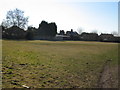
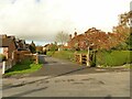
Ettiley Heath Playing Field
The Playing Field was placed in trust by British Salt and is administered by the Ettiley Heath Playing Field Association Charities ref: 520049. For information contact John Davies on [email protected]
Image: © Vicky Muir
Taken: 7 Mar 2010
0.06 miles
2
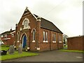
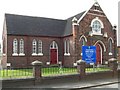
The Church On Ettiley Heath
A former Primitive Methodist church, dated 1888, now an ecumenical place of worship.
Image: © Stephen Craven
Taken: 28 Oct 2024
0.08 miles
3
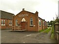
Ettiley Heath Church Community Centre
A former Methodist church hall, dated 1954.
Image: © Stephen Craven
Taken: 28 Oct 2024
0.09 miles
4
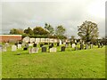
Methodist burial ground, Ettiley Heath
Behind the church Image is this burial ground. It is still in use (latest burial 2023) but only half full, so probably with enough room for another century.
Image: © Stephen Craven
Taken: 28 Oct 2024
0.10 miles
5
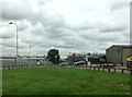
Sandy Lane, Elworth
A narrow, dead-end side street, on which the indicated national speed limit (i.e. 60mph) is optimistic at best.
Image: © Stephen Craven
Taken: 28 Oct 2024
0.12 miles
6
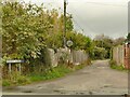
Start of a footpath from Elton Road to Moston Road
This private drive also carries a right of way on foot, which from looking at old maps predates the building of any houses along the route.
Image: © Stephen Craven
Taken: 28 Oct 2024
0.12 miles
9
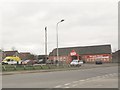
Bargain Booze, Moston Road, Elworth
A national chain of convenience stores that sells much more than alcohol.
Image: © Stephen Craven
Taken: 19 Mar 2016
0.15 miles
10
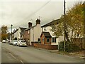
Old cottages, Elton Road, Elworth
Possibly the oldest houses in the area; certainly shown on the 1898 map.
Image: © Stephen Craven
Taken: 28 Oct 2024
0.15 miles