IMAGES TAKEN NEAR TO
Masefield Way, SANDBACH, CW11 3ZJ
Introduction
This page details the photographs taken nearby to Masefield Way, CW11 3ZJ by members of the Geograph project.
The Geograph project started in 2005 with the aim of publishing, organising and preserving representative images for every square kilometre of Great Britain, Ireland and the Isle of Man.

There are currently over 7.5m images from over14,400 individuals and you can help contribute to the project by visiting https://www.geograph.org.uk
Image Map
Images are licensed for reuse under creativecommons.org/licenses/by-sa/2.0
Notes
- Clicking on the map will re-center to the selected point.
- The higher the marker number, the further away the image location is from the centre of the postcode.
Image Listing (14 Images Found)
Images are licensed for reuse under creativecommons.org/licenses/by-sa/2.0
Image
Details
Distance
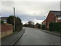
2
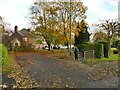
Start of a footpath from Elton Road to Moston Road
This private drive also carries a right of way on foot, which from looking at old maps predates the building of any houses along the route.
Image: © Stephen Craven
Taken: 28 Oct 2024
0.08 miles
3
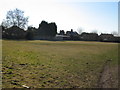
Ettiley Heath Playing Field
The Playing Field was placed in trust by British Salt and is administered by the Ettiley Heath Playing Field Association Charities ref: 520049. For information contact John Davies on [email protected]
Image: © Vicky Muir
Taken: 7 Mar 2010
0.09 miles
5
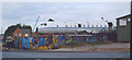
RAF plane
unusual sight to see an RAF plane at a scrapyard
Image: © Linda Craven
Taken: 30 Jul 2006
0.18 miles
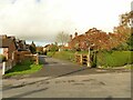
6
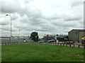
The east end of Proctors Lane
This is a no-through-road for motor traffic, but there is a cycle lane through to Hind Heath Road.
Image: © Stephen Craven
Taken: 28 Oct 2024
0.18 miles
7

Cold war relic at Elworth
The aircraft fuselage is in the yard of Sandbach Commercial Dismantlers and has been for several years. The red star and a few Cyrillic letters suggest it belonged to an Eastern bloc country, but comparing this with the first Geograph for the square in 2006 Image it appears these have been added within the last ten years, replacing the previous RAF roundel. According to the website demobbed.org.uk it is a Hawker Siddeley Andover, built for the RAF in the 1960s. See also Image
Image: © Stephen Craven
Taken: 19 Mar 2016
0.22 miles
8
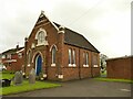
The Church On Ettiley Heath
A former Primitive Methodist church, dated 1888, now an ecumenical place of worship.
Image: © Stephen Craven
Taken: 28 Oct 2024
0.22 miles
10
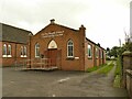
Ettiley Heath Church Community Centre
A former Methodist church hall, dated 1954.
Image: © Stephen Craven
Taken: 28 Oct 2024
0.23 miles