IMAGES TAKEN NEAR TO
Crewe Road, SANDBACH, CW11 3RZ
Introduction
This page details the photographs taken nearby to Crewe Road, CW11 3RZ by members of the Geograph project.
The Geograph project started in 2005 with the aim of publishing, organising and preserving representative images for every square kilometre of Great Britain, Ireland and the Isle of Man.

There are currently over 7.5m images from over14,400 individuals and you can help contribute to the project by visiting https://www.geograph.org.uk
Image Map
Images are licensed for reuse under creativecommons.org/licenses/by-sa/2.0
Notes
- Clicking on the map will re-center to the selected point.
- The higher the marker number, the further away the image location is from the centre of the postcode.
Image Listing (38 Images Found)
Images are licensed for reuse under creativecommons.org/licenses/by-sa/2.0
Image
Details
Distance
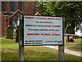
1
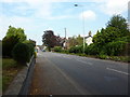
Crewe Road, Wheelock
Looking north from the church
Image: © Alexander P Kapp
Taken: 28 Jul 2011
0.07 miles
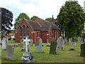
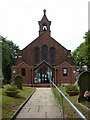
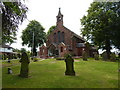
3
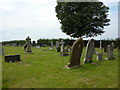
Christ Church, Wheelock, Graveyard
Image: © Alexander P Kapp
Taken: 28 Jul 2011
0.09 miles
4
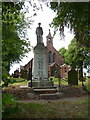
Christ Church, Wheelock, War Memorial
Image: © Alexander P Kapp
Taken: 28 Jul 2011
0.09 miles
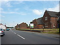
7
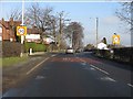
Wheelock - Crewe Road enters from the south
Until the Wheelock bypass was opened in the late 1990s, this was the main route into Crewe from the north.
Image: © Peter Whatley
Taken: 21 Jan 2011
0.09 miles
10
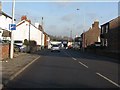
Wheelock - Crewe Road near Mill Lane junction
Image: © Peter Whatley
Taken: 21 Jan 2011
0.14 miles