IMAGES TAKEN NEAR TO
Millcroft, SANDBACH, CW11 3RW
Introduction
This page details the photographs taken nearby to Millcroft, CW11 3RW by members of the Geograph project.
The Geograph project started in 2005 with the aim of publishing, organising and preserving representative images for every square kilometre of Great Britain, Ireland and the Isle of Man.

There are currently over 7.5m images from over14,400 individuals and you can help contribute to the project by visiting https://www.geograph.org.uk
Image Map
Images are licensed for reuse under creativecommons.org/licenses/by-sa/2.0
Notes
- Clicking on the map will re-center to the selected point.
- The higher the marker number, the further away the image location is from the centre of the postcode.
Image Listing (6 Images Found)
Images are licensed for reuse under creativecommons.org/licenses/by-sa/2.0
Image
Details
Distance
1
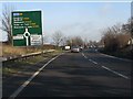
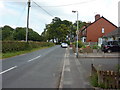
A534 approaching the Wheelock bypass
This section of road - the Haslington bypass - was opened in 1990. The continuation, bypassing the attractive village of Wheelock, was not opened until the late 1990s (either 1998 or 1999).
Image: © Peter Whatley
Taken: 21 Jan 2011
0.14 miles
3
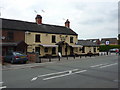
Holly Bush Inn, Crewe Road, Winterley
Image: © Alexander P Kapp
Taken: 28 Jul 2011
0.16 miles
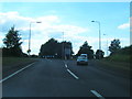
6
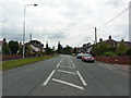
Crewe Road, Winterly
Looking south
Image: © Alexander P Kapp
Taken: 28 Jul 2011
0.22 miles