IMAGES TAKEN NEAR TO
Hind Heath Road, SANDBACH, CW11 3LY
Introduction
This page details the photographs taken nearby to Hind Heath Road, CW11 3LY by members of the Geograph project.
The Geograph project started in 2005 with the aim of publishing, organising and preserving representative images for every square kilometre of Great Britain, Ireland and the Isle of Man.

There are currently over 7.5m images from over14,400 individuals and you can help contribute to the project by visiting https://www.geograph.org.uk
Image Map
Images are licensed for reuse under creativecommons.org/licenses/by-sa/2.0
Notes
- Clicking on the map will re-center to the selected point.
- The higher the marker number, the further away the image location is from the centre of the postcode.
Image Listing (21 Images Found)
Images are licensed for reuse under creativecommons.org/licenses/by-sa/2.0
Image
Details
Distance
2
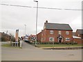
Housing development off Hind Heath Road (1)
A new development on land at Little Hind Heath Farm. The location of the photo is on the corner of Senderfield Lane but the spine road of the new estate is a new road called Trentlea Way.
Image: © Stephen Craven
Taken: 19 Mar 2016
0.13 miles
3
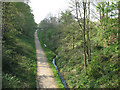
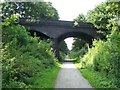
Wheelock Rail Trail
The trail follows the route of the former Sandbach to Kidsgrove railway (part of the North Staffordshire Railway network).
This is the view looking westwards from the bridge seen in Image - the bridge itself is on the gridline which is why the two photos are in different squares.
Image: © Stephen Craven
Taken: 18 Apr 2009
0.14 miles
4
Housing development off Hind Heath Road (2)
A new development on land at Little Hind Heath Farm. The location of the photo is along Senderfield Lane but the spine road of the new estate is a new road called Trentlea Way.
Image: © Stephen Craven
Taken: 19 Mar 2016
0.14 miles
5
Wheelock Rail Trail
This disused railway line has been converted to a path. It runs through Wheelock from Ettiley Heath in the north to join the Trent and Mersey towpath near Malkin's Bank.
Image: © Steve Lewin
Taken: 25 Jul 2006
0.17 miles
6
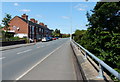
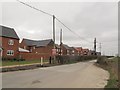
Terraced housing on Crewe Road, Wheelock
Image: © Mat Fascione
Taken: 15 Jul 2015
0.18 miles
7
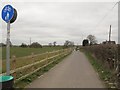
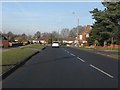
Cycle path alongside Hind Heath Road
The road is a busy one which did not have a footpath. I presume this new segregated shared-use path behind the hedge is part of the "section 106 agreement" with the developers of a nearby housing estate Image But it only runs for a few hundred metres before cyclists have to go back on the road.
Image: © Stephen Craven
Taken: 19 Mar 2016
0.18 miles
8
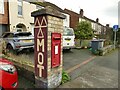
Postbox on Crewe Road
A George VI box outside what was a station building. For a wider context, see Image
Image: © Stephen Craven
Taken: 28 Oct 2024
0.18 miles
9
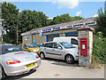
Former Wheelock station building
The front of this building, now a tyre depot, does not look like a former station; but looking round the back it is more obvious Image It also explains the presence of an old postbox.
Image: © Stephen Craven
Taken: 26 Aug 2013
0.18 miles
10
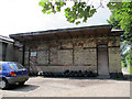
Rear of former Wheelock station building
The station on the North Staffordshire Railway closed in 1930 and the building is now a tyre depot, although from this side the railway style of architecture is evident.
Image: © Stephen Craven
Taken: 26 Aug 2013
0.19 miles