IMAGES TAKEN NEAR TO
Betchton Close, SANDBACH, CW11 1YZ
Introduction
This page details the photographs taken nearby to Betchton Close, CW11 1YZ by members of the Geograph project.
The Geograph project started in 2005 with the aim of publishing, organising and preserving representative images for every square kilometre of Great Britain, Ireland and the Isle of Man.

There are currently over 7.5m images from over14,400 individuals and you can help contribute to the project by visiting https://www.geograph.org.uk
Image Map
Images are licensed for reuse under creativecommons.org/licenses/by-sa/2.0
Notes
- Clicking on the map will re-center to the selected point.
- The higher the marker number, the further away the image location is from the centre of the postcode.
Image Listing (74 Images Found)
Images are licensed for reuse under creativecommons.org/licenses/by-sa/2.0
Image
Details
Distance
1
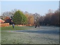
Dog walkers behind the Parkhouse Estate
Several people were exercising their dogs on what is, at least in practice, public land behind the houses.
Image: © Stephen Craven
Taken: 28 Dec 2014
0.02 miles
2
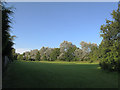
Open space behind the Parkhouse estate
A strip of green space was left between the housing and the A534 Sandbach Bypass (behind the trees to the right). I don't know whether it's technically a public open space but it appears to be used as such.
Image: © Stephen Craven
Taken: 22 Jul 2012
0.03 miles
3
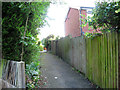
Urban footpath through the Parkhouse estate
The public right of way that ran across the land where the Parkhouse estate was built in the 1980s survives as a series of short urban footpaths like this.
Image: © Stephen Craven
Taken: 22 Jul 2012
0.05 miles
4
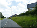
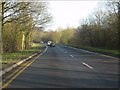
Shared use path alongside the Sandbach Bypass
Phase 1 of the new J One Seven housing development is seen to the right.
Image: © Stephen Craven
Taken: 22 Jun 2019
0.06 miles
5
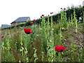
Poppies alongside the Sandbach Bypass
They may have been introduced as part of a wildflower seed mix when the bypass was built, rather than being native to the area. Phase 1 of the new J One Seven housing development is seen in the background.
Image: © Stephen Craven
Taken: 22 Jun 2019
0.07 miles
6
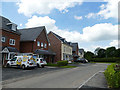
South-eastern corner of J One Seven, looking west
Part of the new J One Seven housing development. This short spur road is so new there is not even a name given for it on the site plan, or on the ground, yet.
Note - location is estimated from the development site plan, as the road is too new to be shown on public maps yet.
Image: © Stephen Craven
Taken: 22 Jun 2019
0.07 miles
8
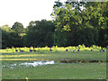
Geese and temporary pond
A gaggle of Canada geese next to a temporary pond formed by heavy rainfall earlier in the week.
Image: © Stephen Craven
Taken: 22 Jul 2012
0.08 miles
9
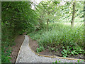
Path into Offley Wood
This path has been recently surfaced in stone, perhaps as part of a "Section 106" agreement relating to the nearby housing development.
Image: © Stephen Craven
Taken: 22 Jun 2019
0.08 miles
10
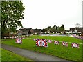
Coronation bunting, Dorfold Close, Sandbach
The Coronation of Charles III was the previous day. If you look closely at the banners you will see they were not acquired specially for this occasion but are re-used from the Diamond Jubilee in 2012. I hope a King who supports recycling would not be offended.
Image: © Stephen Craven
Taken: 6 May 2023
0.08 miles