IMAGES TAKEN NEAR TO
Withington Close, SANDBACH, CW11 1YU
Introduction
This page details the photographs taken nearby to Withington Close, CW11 1YU by members of the Geograph project.
The Geograph project started in 2005 with the aim of publishing, organising and preserving representative images for every square kilometre of Great Britain, Ireland and the Isle of Man.

There are currently over 7.5m images from over14,400 individuals and you can help contribute to the project by visiting https://www.geograph.org.uk
Image Map
Images are licensed for reuse under creativecommons.org/licenses/by-sa/2.0
Notes
- Clicking on the map will re-center to the selected point.
- The higher the marker number, the further away the image location is from the centre of the postcode.
Image Listing (88 Images Found)
Images are licensed for reuse under creativecommons.org/licenses/by-sa/2.0
Image
Details
Distance
1
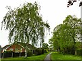
Weeping birch (betula pendula)
This example is at the end of Capesthorne Close.
Image: © Stephen Craven
Taken: 6 May 2023
0.04 miles
2
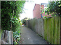
Urban footpath through the Parkhouse estate
The public right of way that ran across the land where the Parkhouse estate was built in the 1980s survives as a series of short urban footpaths like this.
Image: © Stephen Craven
Taken: 22 Jul 2012
0.06 miles
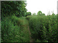
3
Footpath off Doddington Dive
The path, in a strip of grass, runs for several hundred metres along the back of the houses the length of Gawsworth Drive. It also gives access to a larger open space on the edge of the estate Image
Image: © Stephen Craven
Taken: 29 Dec 2015
0.08 miles
4
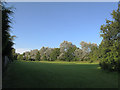
Open space behind the Parkhouse estate
A strip of green space was left between the housing and the A534 Sandbach Bypass (behind the trees to the right). I don't know whether it's technically a public open space but it appears to be used as such.
Image: © Stephen Craven
Taken: 22 Jul 2012
0.08 miles
5
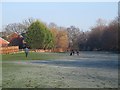
Dog walkers behind the Parkhouse Estate
Several people were exercising their dogs on what is, at least in practice, public land behind the houses.
Image: © Stephen Craven
Taken: 28 Dec 2014
0.09 miles
6
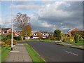
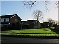
Doddington Drive
Doddington Drive was originally a short, dead-end road like others on the Offley estate (hence the turning area in the photo), but when the adjacent Parkhouse estate was built, it was extended through to link the two.
Image: © Stephen Craven
Taken: 14 Oct 2017
0.09 miles
7
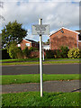
Unusual sign by Doddington Drive
The sign forbids horse riding, cycling and golf practice in the open space off Doddington Drive. Cycling, I can understand, but horses must be pretty rare here, and the specific reference to golf is unusual. See Image for context.
Image: © Stephen Craven
Taken: 14 Oct 2017
0.09 miles
8
Nettles alongside the Sandbach Bypass
An unofficial and somewhat overgrown footpath parallel to the bypass.
Image: © Stephen Craven
Taken: 22 Jul 2012
0.09 miles
9
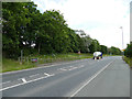
Pedestrian crossing of the Sandbach Bypass
The crossing only offers a safety barrier (on one side) and a refuge in the middle of the road for safety, with no traffic lights. The crossing follows an established right of way pre-dating the road. A milk tanker heads towards the M6 motorway.
Image: © Stephen Craven
Taken: 22 Jun 2019
0.10 miles
10
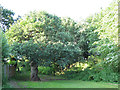
Old oak behind the Parkhouse estate
Most of the trees in this view date from when the Parkhouse estate (left of shot) and bypass (to the right) were built in the 1980s, but a solitary old oak tree survives from an earlier age.
Image: © Stephen Craven
Taken: 22 Jul 2012
0.10 miles