IMAGES TAKEN NEAR TO
Henshall Drive, SANDBACH, CW11 1YN
Introduction
This page details the photographs taken nearby to Henshall Drive, CW11 1YN by members of the Geograph project.
The Geograph project started in 2005 with the aim of publishing, organising and preserving representative images for every square kilometre of Great Britain, Ireland and the Isle of Man.

There are currently over 7.5m images from over14,400 individuals and you can help contribute to the project by visiting https://www.geograph.org.uk
Image Map
Images are licensed for reuse under creativecommons.org/licenses/by-sa/2.0
Notes
- Clicking on the map will re-center to the selected point.
- The higher the marker number, the further away the image location is from the centre of the postcode.
Image Listing (76 Images Found)
Images are licensed for reuse under creativecommons.org/licenses/by-sa/2.0
Image
Details
Distance
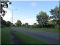
1
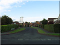
Henshall Drive
Typical of the short side roads on the 1980s Parkhouse estate.
Image: © Stephen Craven
Taken: 22 Jul 2012
0.04 miles
2
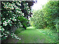
Open space behind the Parkhouse estate
A strip of green space was left between the housing and the A534 Sandbach Bypass (behind the trees to the right). I don't know whether it's technically a public open space but it appears to be used as such. See also Image
Image: © Stephen Craven
Taken: 22 Jul 2012
0.06 miles
3
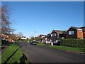
Park House Drive, Sandbach
From the junction with Henshall Drive.
Image: © Stephen Craven
Taken: 29 Dec 2015
0.07 miles
4
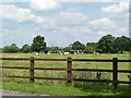
Cows alongside Congleton Road, Sandbach
This field is the last remaining green space on the north side of the road between the town centre and the motorway. I imagine it won't be long before it gets built on.
Image: © Stephen Craven
Taken: 22 Jun 2019
0.07 miles
5
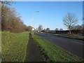
Old Mill Road
Otherwise known as the A534 Sandbach Bypass. Built in the 1980s.
Image: © Stephen Craven
Taken: 22 Jul 2012
0.07 miles
6
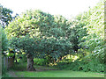
Old oak behind the Parkhouse estate
Most of the trees in this view date from when the Parkhouse estate (left of shot) and bypass (to the right) were built in the 1980s, but a solitary old oak tree survives from an earlier age.
Image: © Stephen Craven
Taken: 22 Jul 2012
0.08 miles
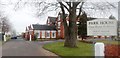
7
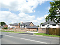
Park House, Congleton Road, Sandbach
The original house at this end has been extended eastwards in a sympathetic style to make quite a large complex of care home accommodation and mews houses. See also Image
Image: © Stephen Craven
Taken: 29 Dec 2015
0.09 miles
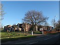
8
Park House Care Home & Mews - Sandbach
Image: © Anthony Parkes
Taken: 24 Nov 2012
0.09 miles
9
Riddell Way, Congleton Road, Sandbach
The latest bit of development on the north side of the road as the town expands towards the motorway. The cows are in for it next Image
Image: © Stephen Craven
Taken: 22 Jun 2019
0.09 miles
10
M16 Junction 17 rebuilding (1)
The approach along Sandbach Bypass (Old Mill Road, A534) from the south-west, before reconstruction work started.
Image: © Stephen Craven
Taken: 28 Dec 2014
0.09 miles