IMAGES TAKEN NEAR TO
Mellors Field Close, SANDBACH, CW11 1TT
Introduction
This page details the photographs taken nearby to Mellors Field Close, CW11 1TT by members of the Geograph project.
The Geograph project started in 2005 with the aim of publishing, organising and preserving representative images for every square kilometre of Great Britain, Ireland and the Isle of Man.

There are currently over 7.5m images from over14,400 individuals and you can help contribute to the project by visiting https://www.geograph.org.uk
Image Map
Images are licensed for reuse under creativecommons.org/licenses/by-sa/2.0
Notes
- Clicking on the map will re-center to the selected point.
- The higher the marker number, the further away the image location is from the centre of the postcode.
Image Listing (67 Images Found)
Images are licensed for reuse under creativecommons.org/licenses/by-sa/2.0
Image
Details
Distance
1
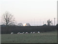
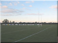
Grazing sheep with distant telescope
A pastoral scene in the foreground, a contrast to the rugby posts behind and Jodrell Bank telescope Image in the far distance (11km away).
Image: © Stephen Craven
Taken: 28 Dec 2008
0.02 miles
2
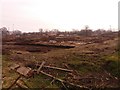
Back of the Bramley Wood development,
While the first houses nearest to Congleton Road were complete by March 2016, those at the back of the development 300m from the main road had yet to be started.
Image: © Stephen Craven
Taken: 12 Mar 2016
0.03 miles
3
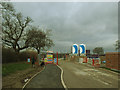
Bramley Wood estate - public footpath
A public footpath runs through the estate. Access has been maintained but walkers are temporarily diverted.
Image: © Stephen Craven
Taken: 19 Mar 2017
0.08 miles
4
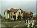
Bramley Wood estate - show houses
The location is approximate and will be confirmed once the new estate is shown on large scale mapping.
Image: © Stephen Craven
Taken: 19 Mar 2017
0.09 miles
5
Sandbach RUFC ground
The ground has several pitches. The club was playing (at the time of submission) in the North 2 West League, according to their website http://www.sandbachrufc.co.uk/
Image: © Stephen Craven
Taken: 28 Dec 2008
0.09 miles
6

Line of trees on Claymore Road
These obviously predate the present housing. Old maps show they formed part of the boundary between field parcels 100 and 101. The left hand pavement follows the route of the original right of way.
Image: © Stephen Craven
Taken: 30 Mar 2024
0.09 miles
7

Utility covers at Bramley Wood
At the northern corner of the estate is this collection of access chamber and valve covers, suggesting both clean and waste water installations.
Image: © Stephen Craven
Taken: 30 Mar 2024
0.10 miles
8
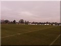
Sandbach Rugby Club
The principal pitch, see also Image
Image: © Stephen Craven
Taken: 12 Mar 2016
0.11 miles
9
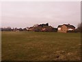
Houses on Marlborough Drive, Sandbach
Some mapping systems give the street name as Malborough Drive but according to the Royal Mail it is the more familiar Marlborough. This view is of the backs of the houses, from the public footpath to Congleton Road.
Image: © Stephen Craven
Taken: 12 Mar 2016
0.11 miles
10
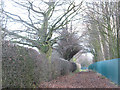
Footpath from Bradwall Road to Offley Road
This unusually broad public footpath runs alongside a school Image, hence the apparent need for a security fence.
Image: © Stephen Craven
Taken: 28 Dec 2008
0.11 miles