IMAGES TAKEN NEAR TO
The Hill, SANDBACH, CW11 1LA
Introduction
This page details the photographs taken nearby to The Hill, CW11 1LA by members of the Geograph project.
The Geograph project started in 2005 with the aim of publishing, organising and preserving representative images for every square kilometre of Great Britain, Ireland and the Isle of Man.

There are currently over 7.5m images from over14,400 individuals and you can help contribute to the project by visiting https://www.geograph.org.uk
Image Map
Images are licensed for reuse under creativecommons.org/licenses/by-sa/2.0
Notes
- Clicking on the map will re-center to the selected point.
- The higher the marker number, the further away the image location is from the centre of the postcode.
Image Listing (13 Images Found)
Images are licensed for reuse under creativecommons.org/licenses/by-sa/2.0
Image
Details
Distance
1
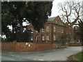
Hill House (old building), Sandbach
This is a grade 2 listed property dating from c.1870 and 1912 (list entry 1330402). In the mid-late 20th century it became the Leonard Cheshire Home, in which role it is now superseded by a newer purpose-built facility next door Image It is now vacant, but reputedly haunted by the ghosts of former residents.
Image: © Stephen Craven
Taken: 19 Mar 2017
0.02 miles
2
New entrance to Hill House
Hill House is a Leonard Cheshire home, providing a range of services for adults with physical disabilities. This vehicular entrance off The Hill provides a more direct route into the grounds than previously.
Image: © Stephen Craven
Taken: 19 Mar 2017
0.03 miles
3
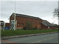
Barn on The Hill near Sandbach
The barn, or possibly workshop, would have been part of the estate of Hill House Image New houses in the grounds of the old house can be glimpsed to the left of the photo.
Image: © Stephen Craven
Taken: 19 Mar 2017
0.04 miles
4
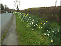
Daffodils on The Hill near Sandbach
This was as far as I walked out of the town centre, to just beyond the last buildings and the end of the 30mph speed limit.
Image: © Stephen Craven
Taken: 19 Mar 2017
0.07 miles
5
Oakley House, The Hill, Sandbach
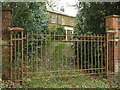
Glimpsed through the gates, this is a grade 2 listed property dating from c.1820 (list entry 1130361).
Image: © Stephen Craven
Taken: 19 Mar 2017
0.07 miles
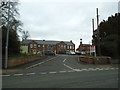
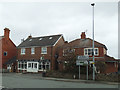
6
Heath Road Garage, Sandbach
A MOT testing station. Beyond it is a Premier convenience store.
Image: © Stephen Craven
Taken: 1 Jan 2016
0.18 miles
7
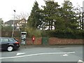
Phone box and post box, Hassall Road
Opposite the end of Stringer Avenue.
Image: © Stephen Craven
Taken: 19 Mar 2017
0.19 miles
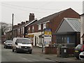
8
Top of the Hill Chip Shop
Opposite the end of Hassall Road.
Image: © Stephen Craven
Taken: 19 Mar 2017
0.20 miles
9
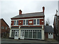
Former Co-Operative Store, The Hill, Sandbach
The building bears the date 1897 and the name of the Sandbach Industrial Co-Operative Society Ltd. It is currently vacant.
Image: © Stephen Craven
Taken: 19 Mar 2017
0.21 miles
10
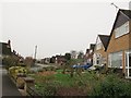
Hawthorne Drive, Sandbach
Viewed from the Heath Road end.
Image: © Stephen Craven
Taken: 1 Jan 2016
0.21 miles