IMAGES TAKEN NEAR TO
Welles Street, SANDBACH, CW11 1JR
Introduction
This page details the photographs taken nearby to Welles Street, CW11 1JR by members of the Geograph project.
The Geograph project started in 2005 with the aim of publishing, organising and preserving representative images for every square kilometre of Great Britain, Ireland and the Isle of Man.

There are currently over 7.5m images from over14,400 individuals and you can help contribute to the project by visiting https://www.geograph.org.uk
Image Map
Images are licensed for reuse under creativecommons.org/licenses/by-sa/2.0
Notes
- Clicking on the map will re-center to the selected point.
- The higher the marker number, the further away the image location is from the centre of the postcode.
Image Listing (359 Images Found)
Images are licensed for reuse under creativecommons.org/licenses/by-sa/2.0
Image
Details
Distance
1
Light and Life Church, Bradwall Road, Sandbach
The building is marked as a church or chapel on older maps but I presume its name has changed at some point.
Image: © Stephen Craven
Taken: 17 Oct 2021
0.02 miles
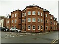
2
Bradwall Court, Sandbach
A small business centre on Bradwall Road.
Image: © Stephen Craven
Taken: 17 Oct 2021
0.02 miles
3
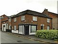
2 Chapel Street, Sandbach
What looks like a shop premises, but currently vacant. Note the old valve markers on the wall: one says FP for Fire Point, 20 1/2 feet, and the other V (valve) 7ft.
Image: © Stephen Craven
Taken: 17 Oct 2021
0.02 miles
4
Modern building, Bradwall Street, Sandbach
On the corner of Wesley Street.
Image: © Stephen Craven
Taken: 17 Oct 2021
0.03 miles
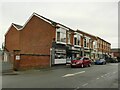
5
Bold Street: Oxfam shop
The charity shop occupies the western end of the former Co-operative building Image and the start of the next building.
Image: © Stephen Craven
Taken: 26 Jul 2014
0.03 miles
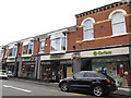
6
Shops on the north side of Bold Street, Sandbach
The ones nearest the camera are currently a nail bar, dry cleaners, takeaway and Oxfam charity shop.
Image: © Stephen Craven
Taken: 17 Oct 2021
0.03 miles
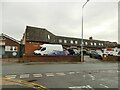
7
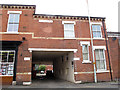
Welles Street: entrance to Embury Court
Access to this development is through a flat-ceilinged underpass.
Image: © Stephen Craven
Taken: 26 Jul 2014
0.03 miles
8
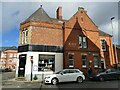
Former bank building, Bold Street, Sandbach
The building is now occupied by the 'Sandbach Art Room' and 'Kast Medical Aesthetics'.
Image: © Stephen Craven
Taken: 15 Oct 2022
0.03 miles
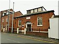
9
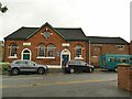
Former Providence School, Chapel Street, Sandbach
A former primary school, dating from 1869. Unlike the nearby Sunday School of similar date Image it is not listed, and is currently used by the Scouts.
Image: © Stephen Craven
Taken: 17 Oct 2021
0.03 miles
10
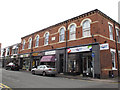
Bold Street: former Co-operative building
This building was the Sandbach Industrial Co-operative Society Limited, comprising a factory and shop and built in 1877. The ground floor is now let as four shop units, the nearest being Age UK, opened in 2013.
Image: © Stephen Craven
Taken: 26 Jul 2014
0.04 miles