IMAGES TAKEN NEAR TO
Firth Close, SANDBACH, CW11 1JH
Introduction
This page details the photographs taken nearby to Firth Close, CW11 1JH by members of the Geograph project.
The Geograph project started in 2005 with the aim of publishing, organising and preserving representative images for every square kilometre of Great Britain, Ireland and the Isle of Man.

There are currently over 7.5m images from over14,400 individuals and you can help contribute to the project by visiting https://www.geograph.org.uk
Image Map
Images are licensed for reuse under creativecommons.org/licenses/by-sa/2.0
Notes
- Clicking on the map will re-center to the selected point.
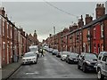
- The higher the marker number, the further away the image location is from the centre of the postcode.
Image Listing (300 Images Found)
Images are licensed for reuse under creativecommons.org/licenses/by-sa/2.0
Image
Details
Distance
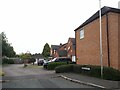
1
Malt Kiln Way, Sandbach
An early 21st century housing development, on the site of Malt Kiln Farm. None of the farm buildings survive apart from a few cottages on Offley Road.
Image: © Stephen Craven
Taken: 17 Aug 2024
0.05 miles
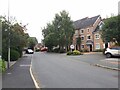
2
Pavilion Place, Sandbach
Part of an early 21st century housing development, on the site of Malt Kiln Farm. None of the farm buildings survive apart from a few cottages on Offley Road but they would have been to the left of this photo.
Image: © Stephen Craven
Taken: 17 Aug 2024
0.06 miles
3
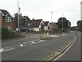
A recent roundabout on Bradwall Road, Sandbach
Recent, because it was created a few years ago in giving access to a new housing development (Malt Kiln Way, left).
Image: © Stephen Craven
Taken: 17 Aug 2024
0.08 miles
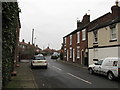
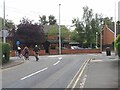
5
Welles Street
Welles Street and Green Street were added to the Town Centre Conservation Area as an example of Victorian development. There has been consultation on omitting the northern 'residential' part of both streets due to previous inappropriate modifications to properties. This pragmatic approach would appear to make sense.
Image: © John M
Taken: 20 Oct 2017
0.09 miles
6
Another roundabout on Bradwall Road, Sandbach
Bradwall Road curves to the right here, with the cyclists turning left on to Offley Road.
Image: © Stephen Craven
Taken: 17 Aug 2024
0.09 miles
7
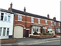
The Old Bakery, Bradwall Road, Sandbach
A mid-20th century map shows the bakery being a long, narrow behind these buildings, accessed through the archway shown here.
Image: © Stephen Craven
Taken: 17 Aug 2024
0.09 miles
8
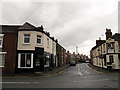
Newfield Street
A dead-end street off Congleton Road. On the corner is what was for many years an independent hardware shop, and more recently a hairdressers Image, but as of 2012 vacant again.
Image: © Stephen Craven
Taken: 31 Dec 2012
0.11 miles
9
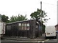
Green Street: old garage
This wooden shed housing a vehicle repair workshop looks to be a survivor from an earlier age.
Image: © Stephen Craven
Taken: 26 Jul 2014
0.11 miles
10
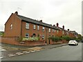
Houses on Bradwall Road, Sandbach
Brick houses, fairly typical of the town.
Image: © Stephen Craven
Taken: 17 Oct 2021
0.11 miles